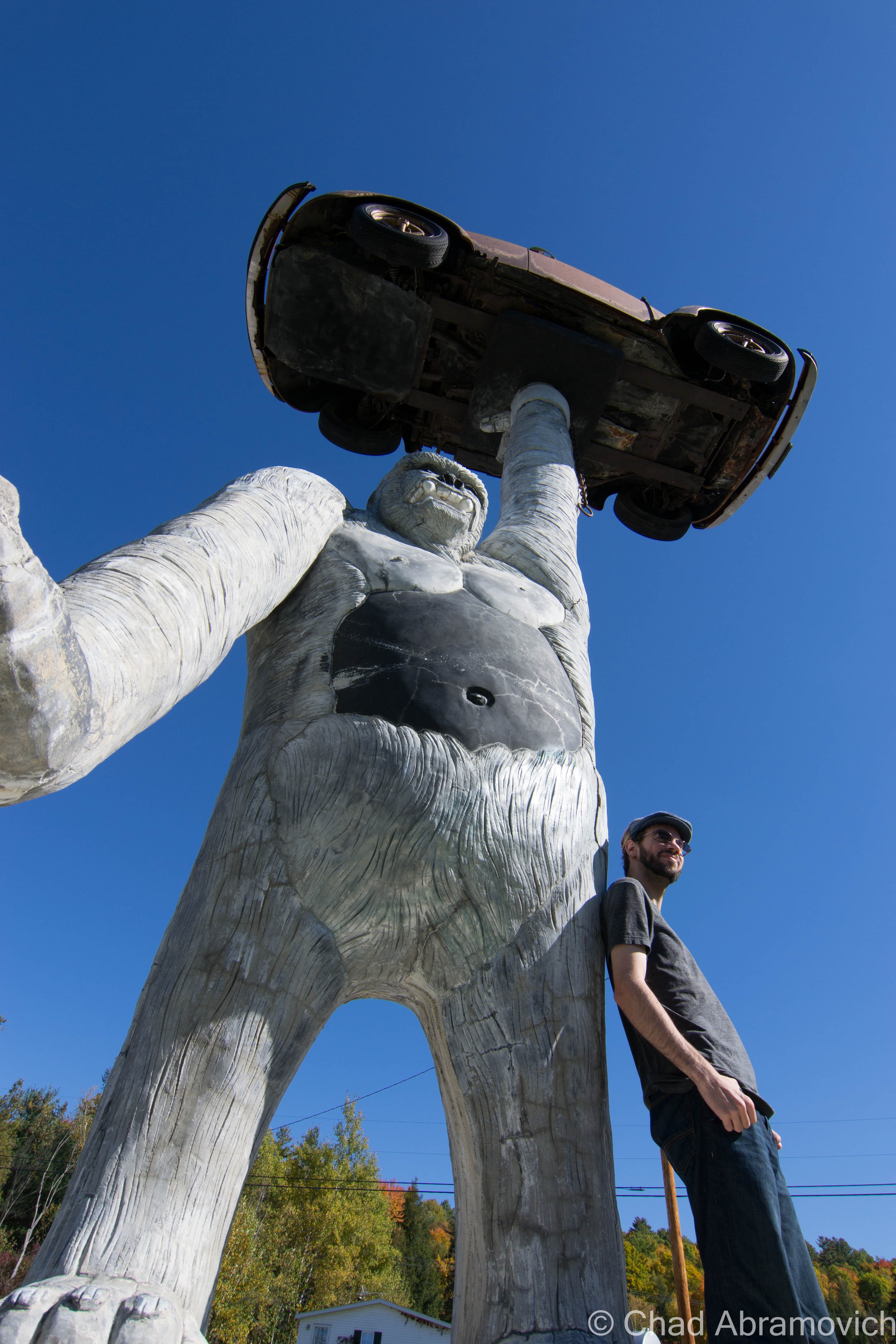
Hogback Mountain and A 100 Mile View

Queen Connie

Vermont’s roads are pretty regulated, so there isn’t much here in terms of weird or kitschy personalized properties that people like to put into the broad category of roadside Americana – which includes a perpetually growing compilation of the same genre (nonstandardized) but vary widely in sentiment and imagery.

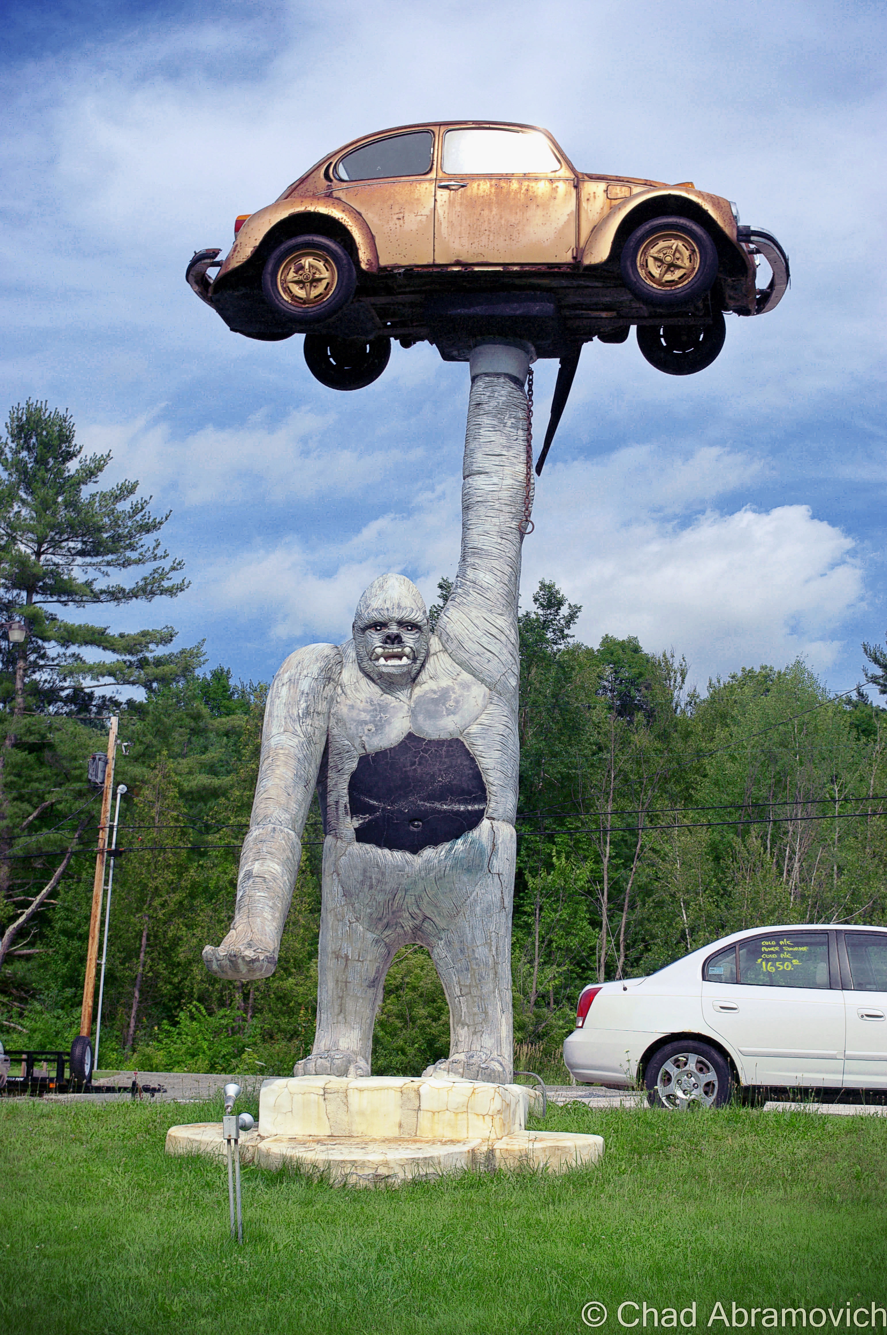
But, that doesn’t mean obscurities can’t be found along Vermont’s byways. Take the tiny farm town of Leicester, whose most famous denizen can be seen lumbering over the small oval-shaped lawn of Pioneer Auto Sales, right along the side of Route 7 either before or after you approach the tiny village center – which is pretty much an intersection with a few houses and a newly reopened gas station that now has a growler filling station.

“Queen Connie”, which it’s sometimes referred as when it’s not called “that big gorilla holding the VW bug”, is a huge 20-ft. tall, 16 ton, concrete ape, holding up a progressively rotting Volkswagon Beetle in one of her upraised arms, while the other arm is stretched out, palm upward, acting as a place where someone could grab an uncomfortable seat and a gimmicky photo opportunity.

But how did something like Queen Connie end up in aesthetic conscious Vermont? And what’s the story behind it? Actually, the answer is pretty straight forward – according to what I was told anyways. The owner of the car dealership had commissioned local artist T.J. Neil to do some concrete work around his pool at home. He was impressed with Neil’s work, and casually suggested another project; to do something cool to spruce up his business. Neil surprised him by suggesting a hyperbolized gorilla – his only reason was because he wanted to see it holding up a car. In 1987, Queen Connie was constructed using steel reinforced concrete, and she’s been observing activity on Route 7 with a disgruntled facial expression ever since, and for Vermonters who are into the weird, might be one of their first forays into oddity hunting.

Though I’m glad Vermont isn’t carelessly overdeveloped like other states, emblems like this are a pejorative thing to build here in the present tense, so it makes it all the more enjoyable.

dsc_0785_pe
Your blogger and local weird worker, posing for a photo.

dsc_0110_pe

Up The Molly Stark Trail

I was heading down to explore parts of southern Vermont with a friend. My summer turned into a lot of stress and setbacks, and I felt like my life was becoming as standard as my white apartment walls. My prescription was a long drive, and the lure of autumn’s sway just makes road trips better. Passing through my favorite town of Wallingford always cures a frown on my face, and as we got farther south and the trees began to turn gold in the hills around Mount Tabor and Dorset, I enthusiastically recalled a defunct marble quarry I hiked to last summer.

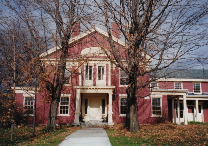
Route 7 turns into a limited access highway through most of Bennington County, until it reverts back to full access in Bennington and brings you right into its historic downtown district, the center of town being where it intersects with state route 9. I took a quick jaunt up the hill to the Old Bennington neighborhood to take a few photos of one of my favorite buildings in Vermont, The Walloomsac Inn, then ventured up route 9 eastwards into the mountains.

dsc_0399_pe
The Walloomsac Inn, my favorite haunt in Bennington.

Route 9, also known as The Molly Stark Trail or The Molly Stark Byway as the state issued scenic byway signs tell you –  is one of my favorite drives in Vermont, and the same sentiment could probably be said for quite a few other people. It’s an extraordinary road to gawk at through the windshield of your car, and even better when you’re stopping to get out and look around. The mountain road twists and turns through the innards of the national forest and gains elevation and grade pretty much as soon as you get beyond Bennington’s limits as it starts to climb the first of many hills and parallels the boulder filled Walloomsac River. To be honest, lots of things on this road vie for your attention.

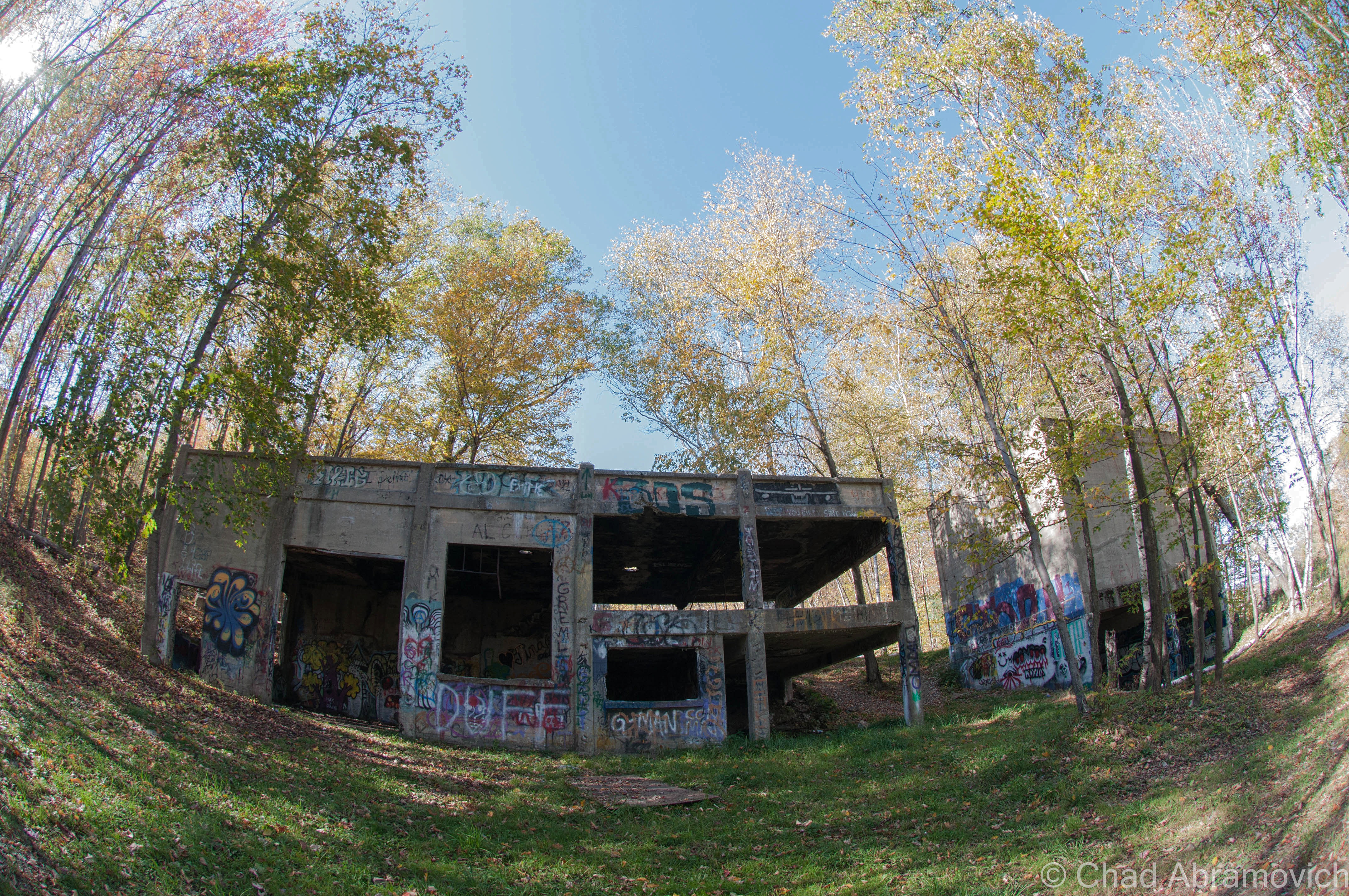
A sense of awe and anticipation builds in me when I see a trademark brown and white national forest sign, telling drivers that there are various access spaces to Vermont’s Green Mountain National Forest for the next 15 miles or so. That includes the massive Glastenbury wilderness, one of Vermont’s largest undeveloped areas, but more known for the titular defunct town and about 2 centuries worth of weirdness that culminated on its many slopes and took off like a contagion shotgun blast into paranormal sensationalism. But it”s hard not to be fascinated by the large expanse of wilderness. The huge area holds ghost towns, a slew of trails and forest roads, man-made feats of engineering, and plenty of mysteries. Just ask the Geocaching community.

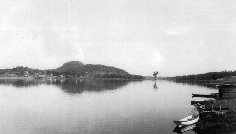
We passed through forested Woodford, the highest town in elevation in Vermont at around 2,215 feet, then descended into Wilmington. Which is where I unintentionally found some local curio. A green 1915 iron truss bridge first caught my eye, because it was obviously abandoned, as indicated by all the trees growing through it. The underwhelming replacement was a simple concrete and steel span that bridged the river inches away. As I was gazing at the bridge, I noticed a strange white sign across the bridge that was put up on a small weedy embankment that welcomed me to “Medburyville”, and gave me a precise census of 31 people and 26 pets who I guess lived somewhere nearby in the rural area.

I was at a loss here. The area around the sign was pretty much an undeveloped light wilderness area, and I knew that we had already crossed the Woodford/Wilmington town line. I’m a pundit on Vermont geography and had never heard of Medburyville before, so I was pretty curious. What was/is Medburyville? A local parody or some kind of irony? A name of an obscure back road Wilmington neighborhood?

My camera was acting up, so looks like Google street view will have to suffice for an image of the sign.

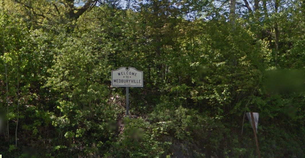
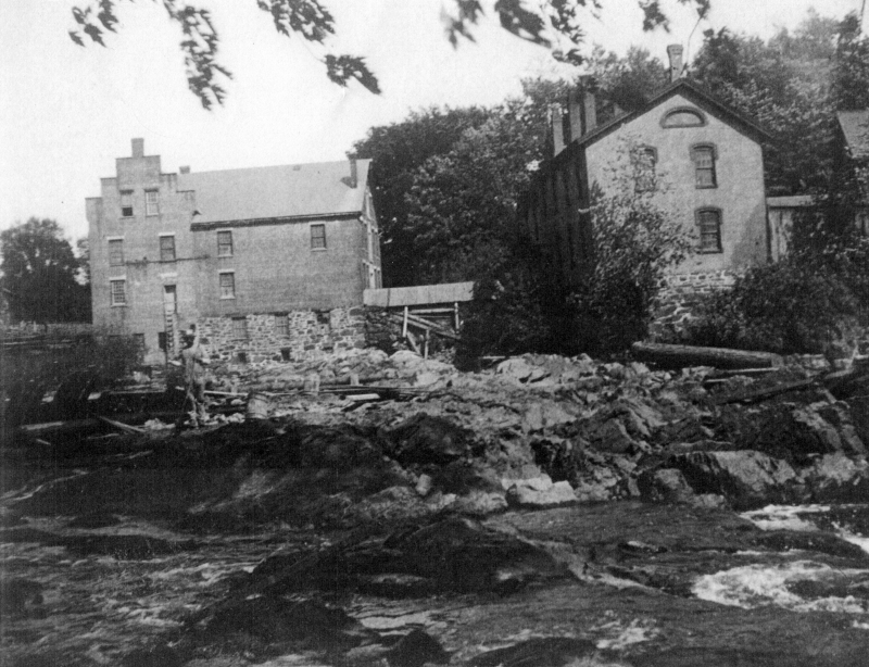
I was curious if there was a mystery or story here, so I sent an email to the Wilmington Historical Society. In their reply, Julie Moore explained that Medburyville was a village in Wilmington, but was erased when the Harriman Reservoir was constructed for the purpose of flood control. There was a mill, several houses and a railroad line that ran through the area at one point.

Today there is only a small aluminum sign that raises more questions than answers. Just a few feet from what was/is the Medburyville area is a narrow arm of the aforementioned reservoir, which is experiencing pretty low water levels lately so it was more sandbars than water when I drove by. Local lore has it that when the reservoir is low, a slimy church steeple from the former village is exposed, but I didn’t see anything that day that looked out of place in a reservoir.

Another obscure footnote is that there once was a placename along the reservoir that had the post office address of “Surge Tank” – a name of a temporary settlement that sheltered the men who built the Harriman Reservoir dam that had it’s own recognized post office. The post office also moved around between Readsboro and Whittingham – depending on wherever construction was happening. I still see Surge Tank sometimes on obscure place name lists. Like Medburyville, Surge Tank is long gone, and without a sign to commemorate it.

Back on the road, the forests occasionally break up a little and you got a positioning glimpse that you were right in the middle of the green mountain chain. Unlike some parts of Vermont where a high elevation isn’t surrounded by other mountains and instead reduces off into valleys, the mountains around Wilmington and Marlboro stretched as far as the vistas, with various 440 million-year eroded summits slanting into other rounded domes. A few “runaway truck ramps” with large yellow signs and rhythmic blinking lights were a reminder that the undulating byway had the potential to be more dangerous than scenic for other drivers, and judging by the scars and pit marks in one of them, it had been used recently.
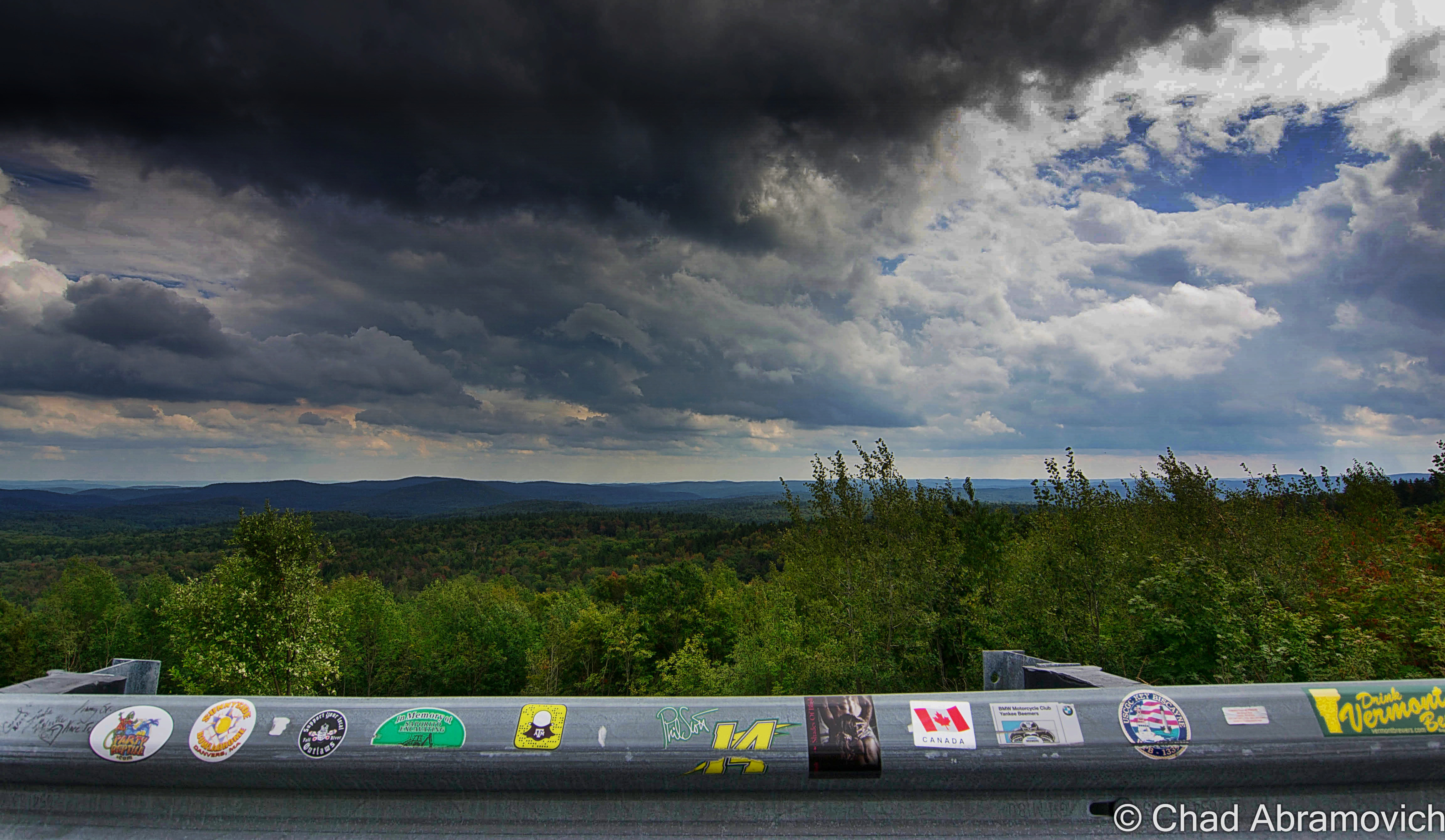
The “100-Mile View”

But it was the so-called “100-mile view” in Marlboro that was the most impressive. I’m not sure if that name is superlative or not, but I suppose it doesn’t really matter because the view is awesome. From a large wooden deck with coin functioning viewing apparatuses for the tourist crowd, you can see what’s left of southern Vermont before it transitions into the Berkshire Hills, and the bumps of southern New Hampshire, including Mount Monadnock.

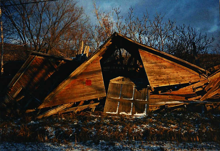
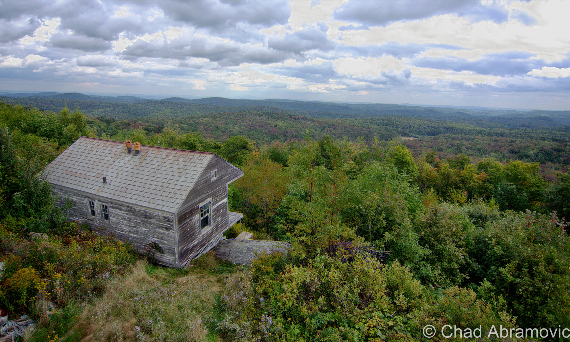
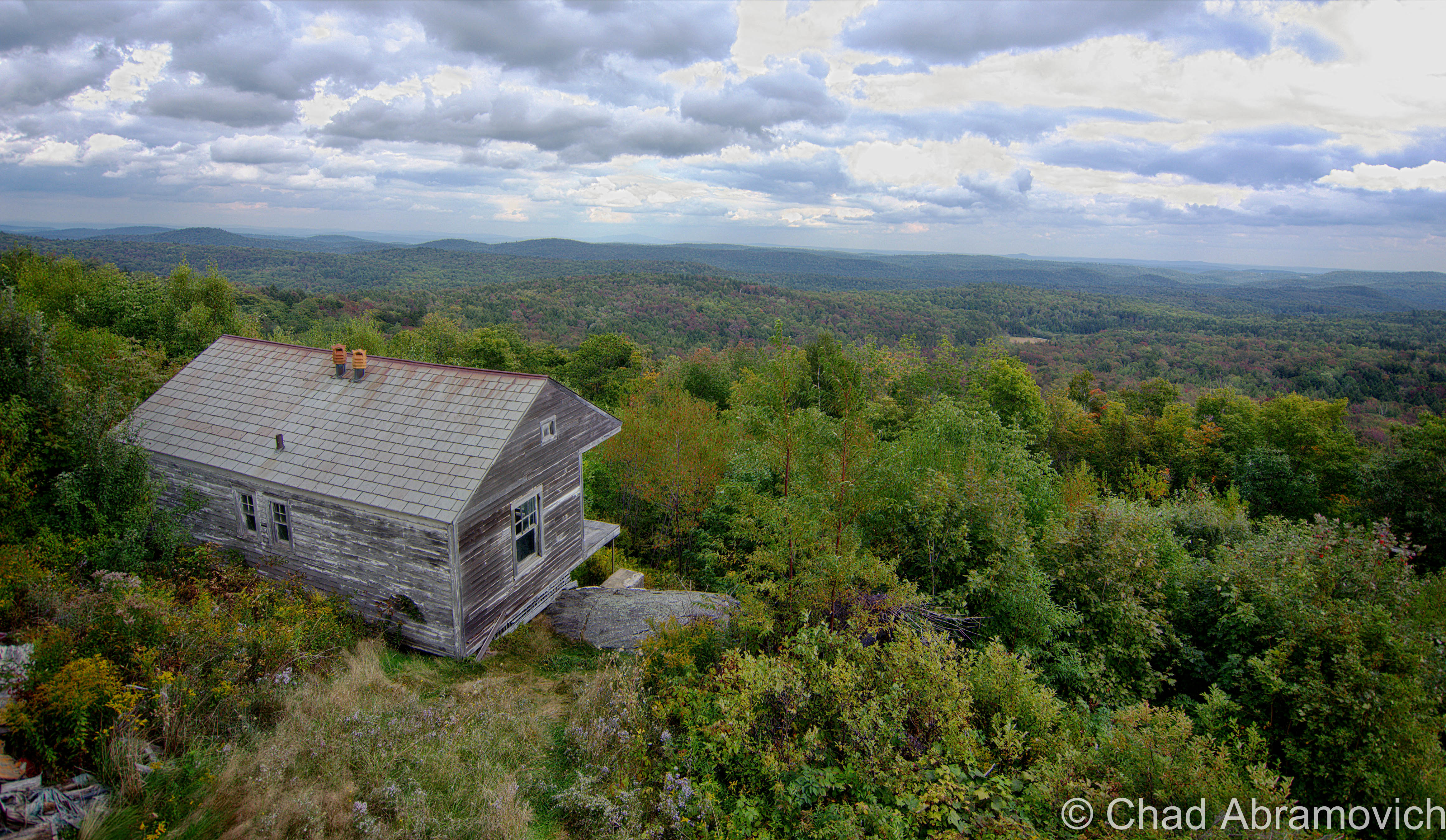
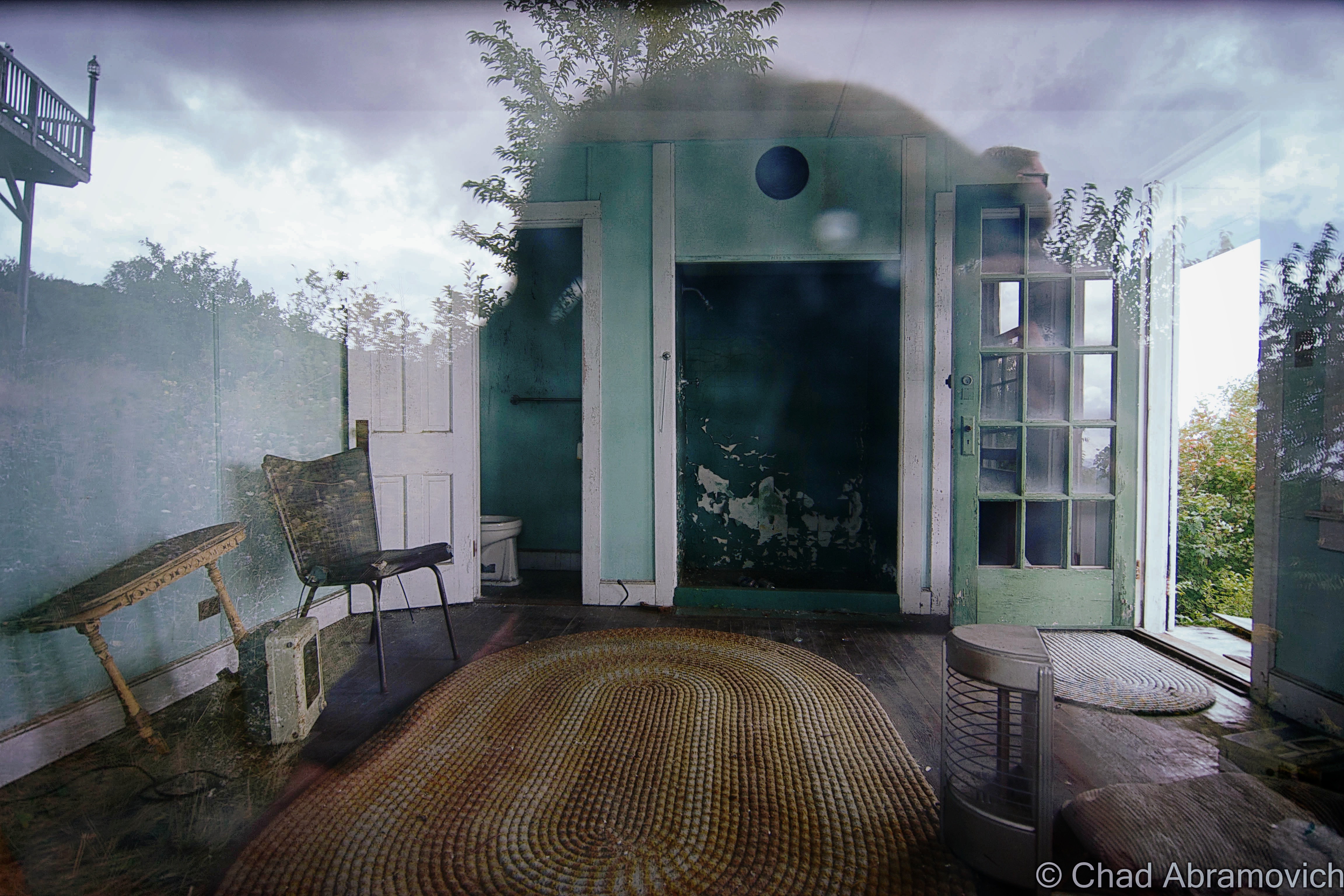
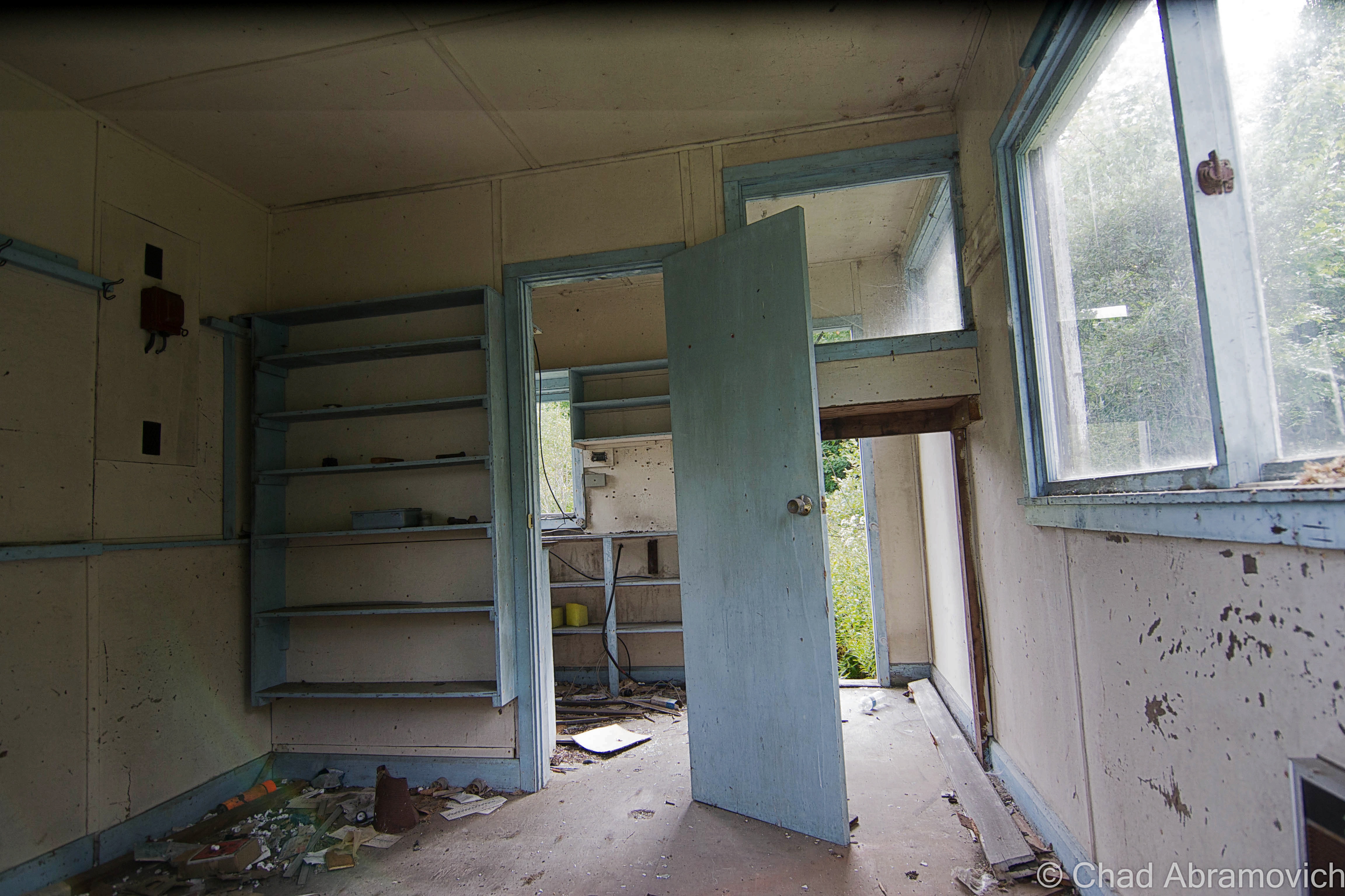
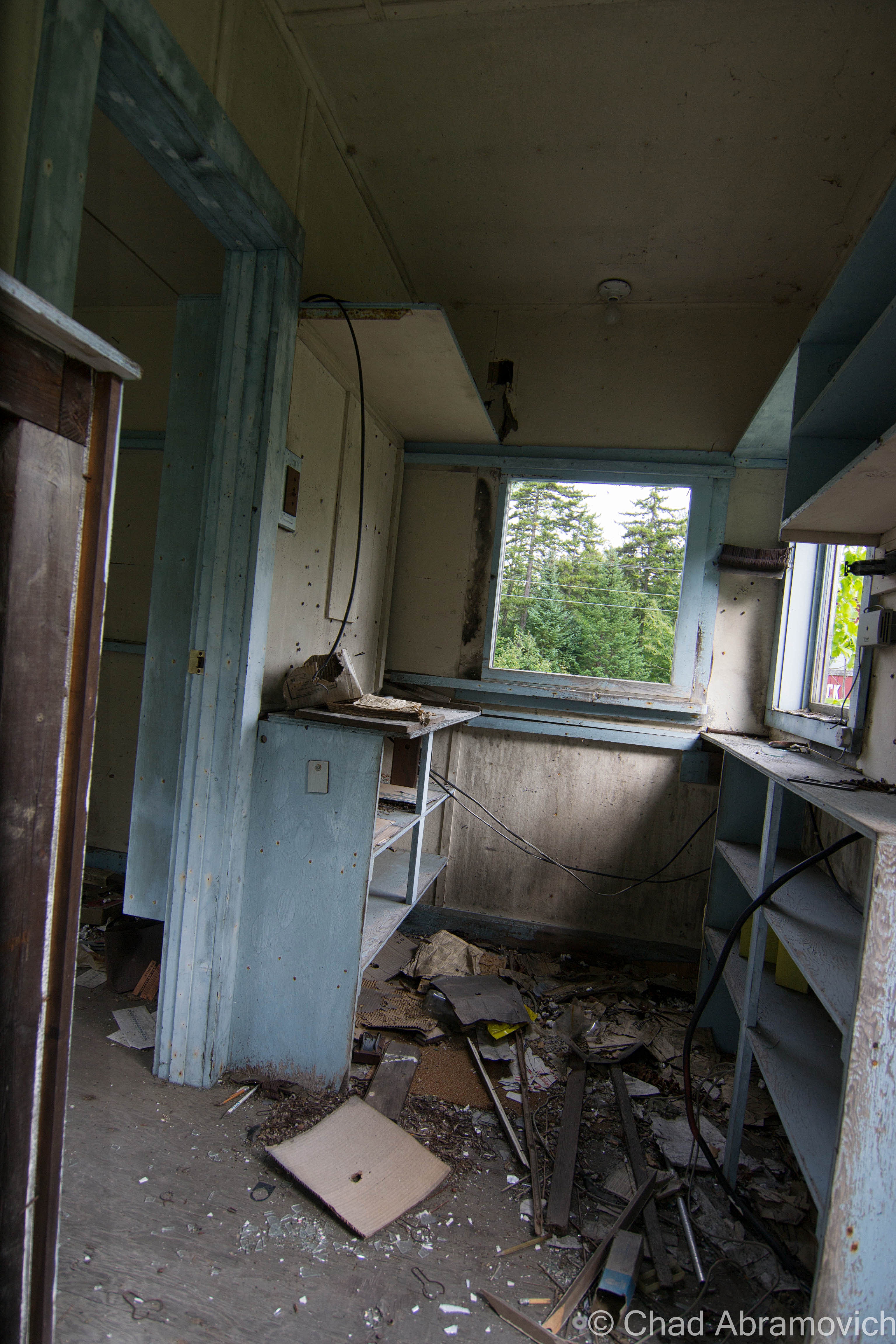
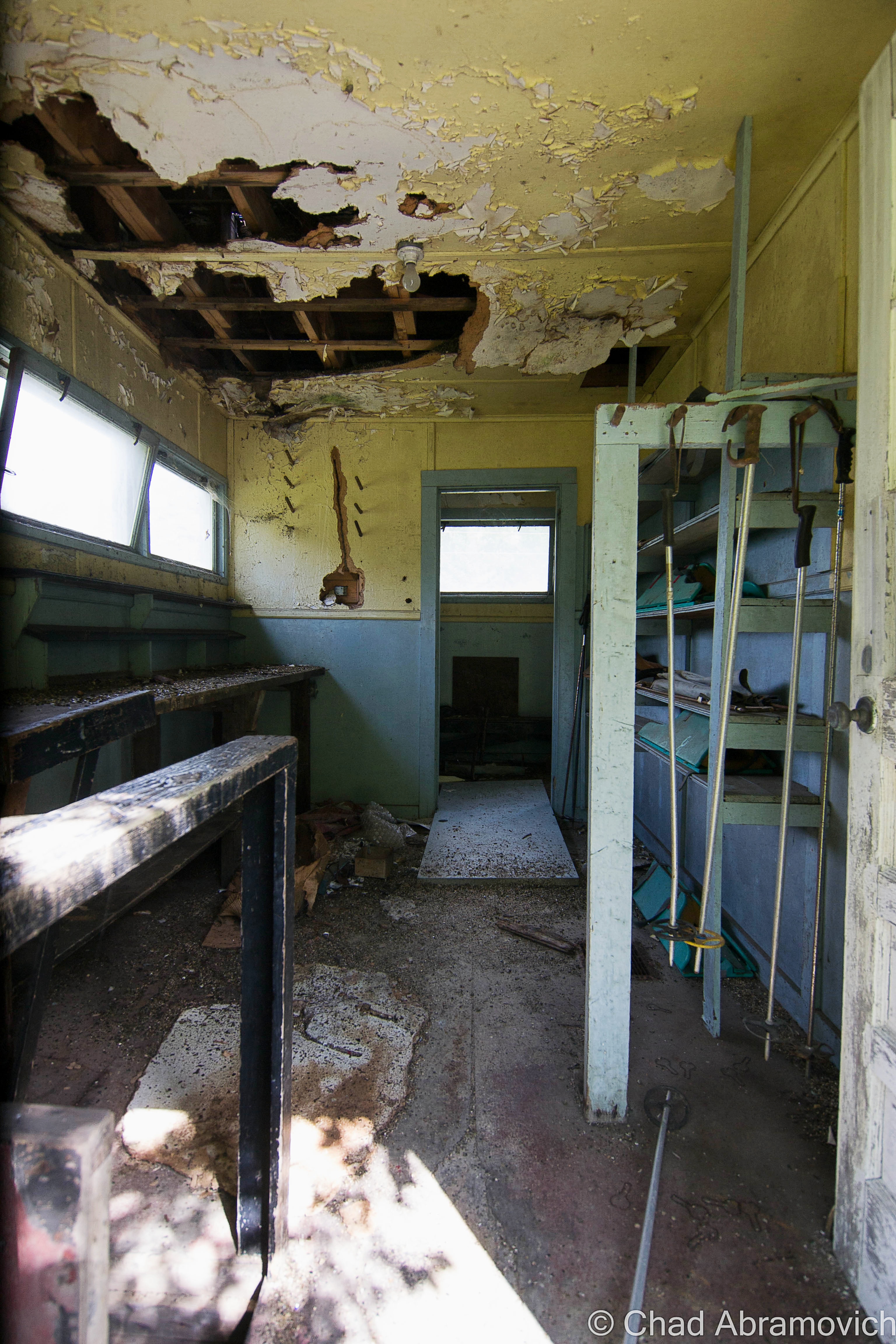
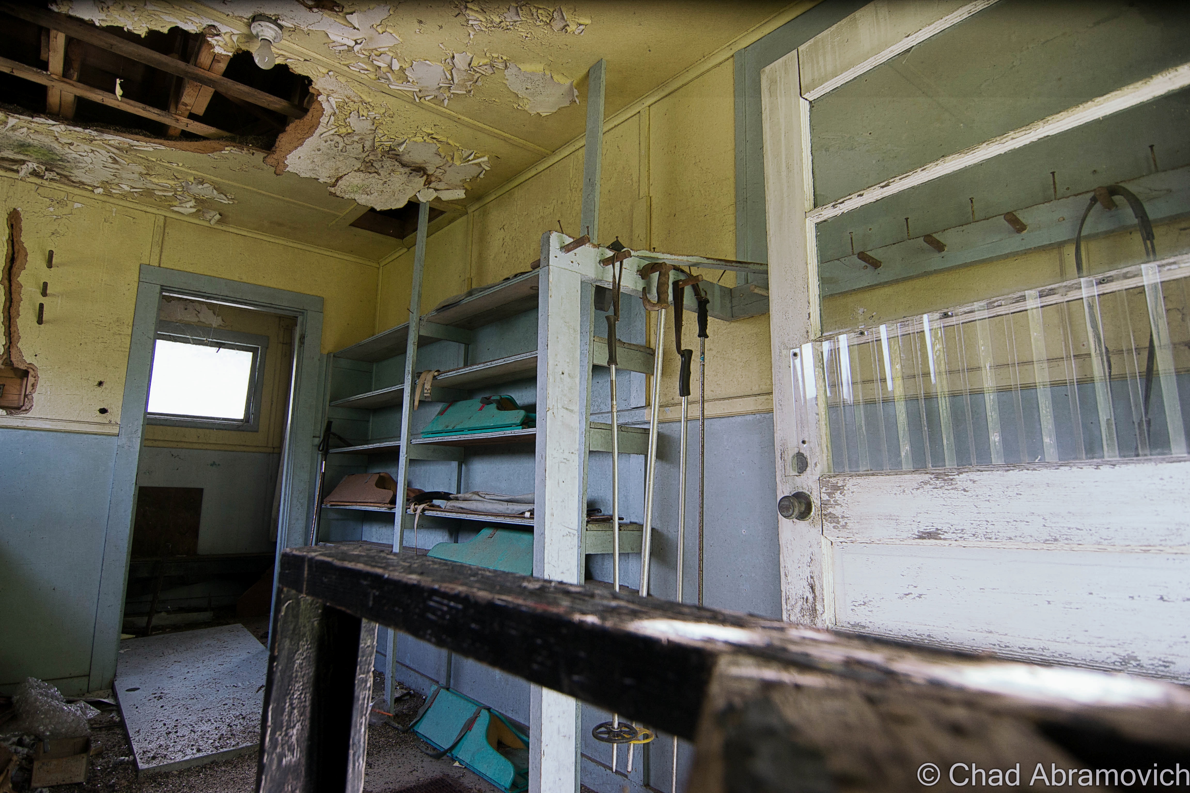
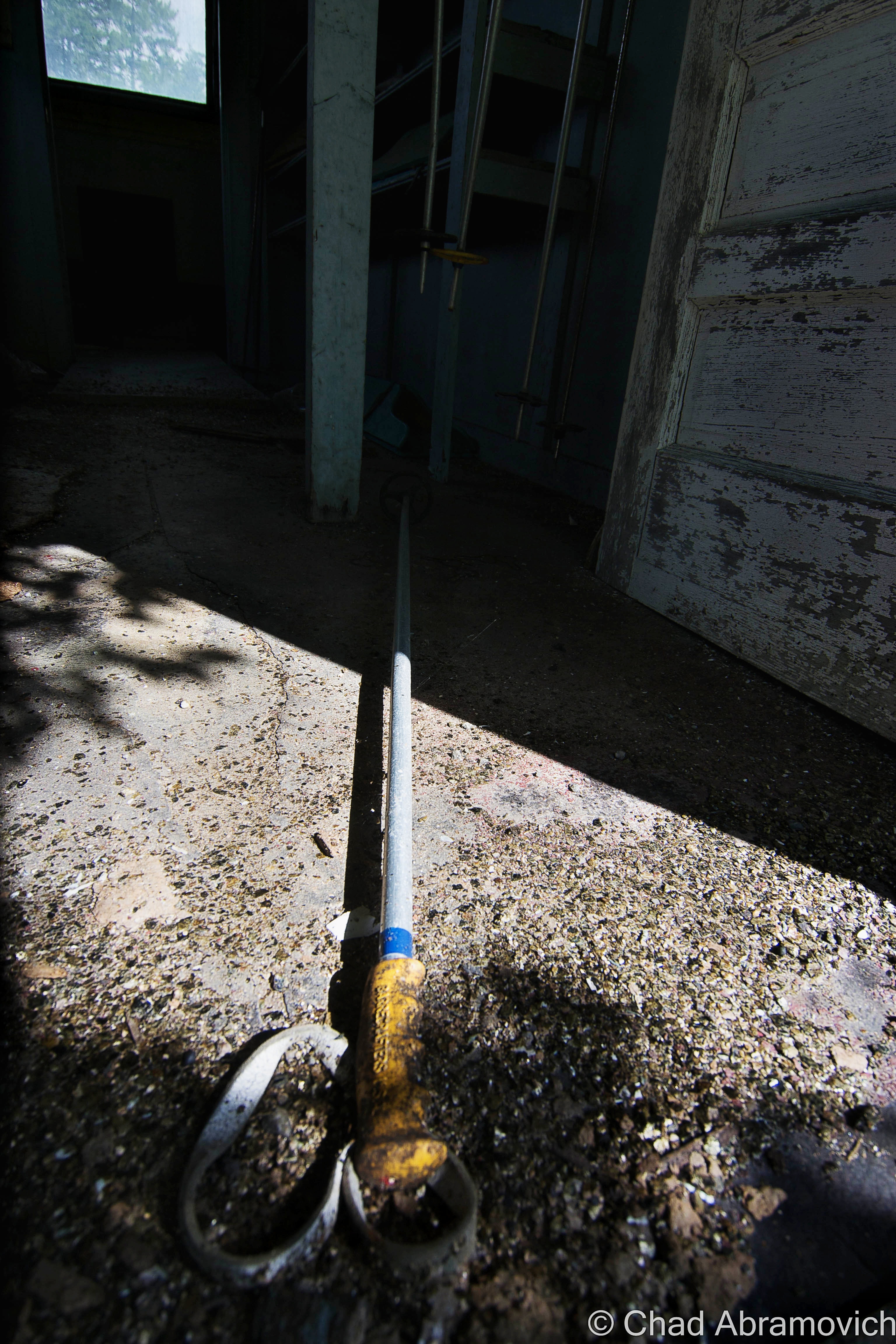
One of the ramshackle old lodging cabins from a deceased ski resort, which I was about to hike to, sits on the edge of a drop off below the overlook, and might be one of the most photographed site among the sights. I took a walk down, and there was a laminated sign taped to the twisting floorboards telling people like myself to keep out – it’s not actively maintained (as evident by the peeling paint) and can be dangerous if the building decides to tumble down the hill. But I was able to get a shot through a dusty old window along the side and gaze curiously at a few items of older furniture left inside.

I live in Vermont’s largest city, and dig the scene there, but sometimes my hometown is just too oversaturated with people for my taste. I really ache for having access to land like I did when I was younger, where I could go 4 wheeling and hiking and just let out the things storming in my mind. So my predilection was that I could sit on that porch all day or night and gaze off into the distance in my own reverie, listening to Gregory Alan Isakov albums. 

dsc_0413_pe
It seems like I was racing storms all day as I traveled around the state yesterday. They finally caught up with me at the top of the Molly Stark Trail, one of Vermont’s most scenic byways. Someone once told me how the few street signs (mostly stop signs) in Greenland’s research bases and camp cities are completely coated with stickers. It’s a way to get the story of its visitors or inhabitants. Where you’re from, what you like, what you stand for, etc. I thought that was pretty cool, and remembered that when I saw the guardrail that hemmed in the road atop Hogback Mountain. Though that’s not quite the case in Vermont, I’ve seen a few guardrails covered in visitor mementos, many just confessing fannish love for various companies or organizations, alongside sharpied graffiti, names and dates. Appalachian Gap on state route 17 has a similar theme.

dsc_0422_pe

The cluster of tourist buildings that sort of delineate the maximum height of land between Bennington and Brattleboro were all once a part of Hogback Mountain, a defunct ski area cut out of the slopes of Mount Olga which has mostly been recovered by nature.

Hiking Around Hogback Mountain

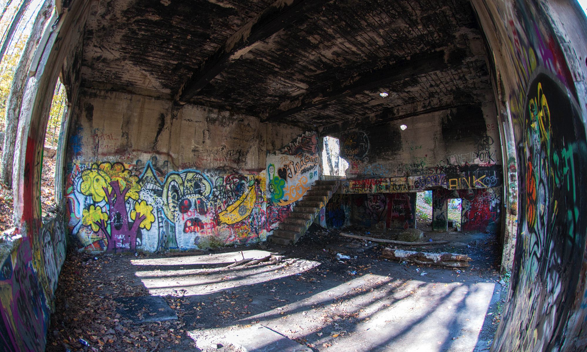
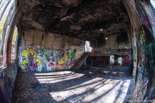
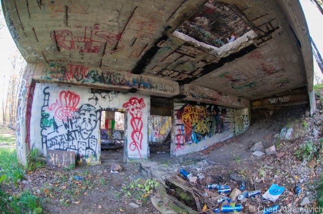
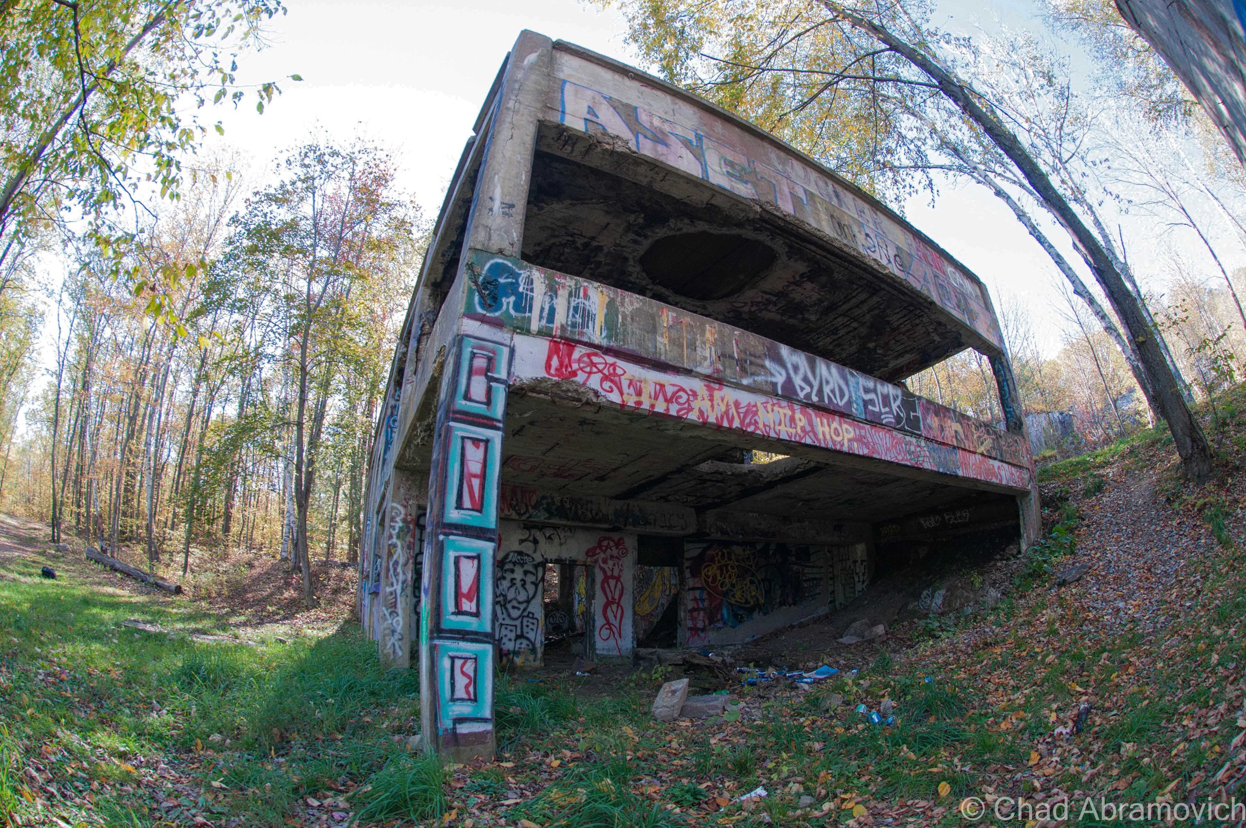
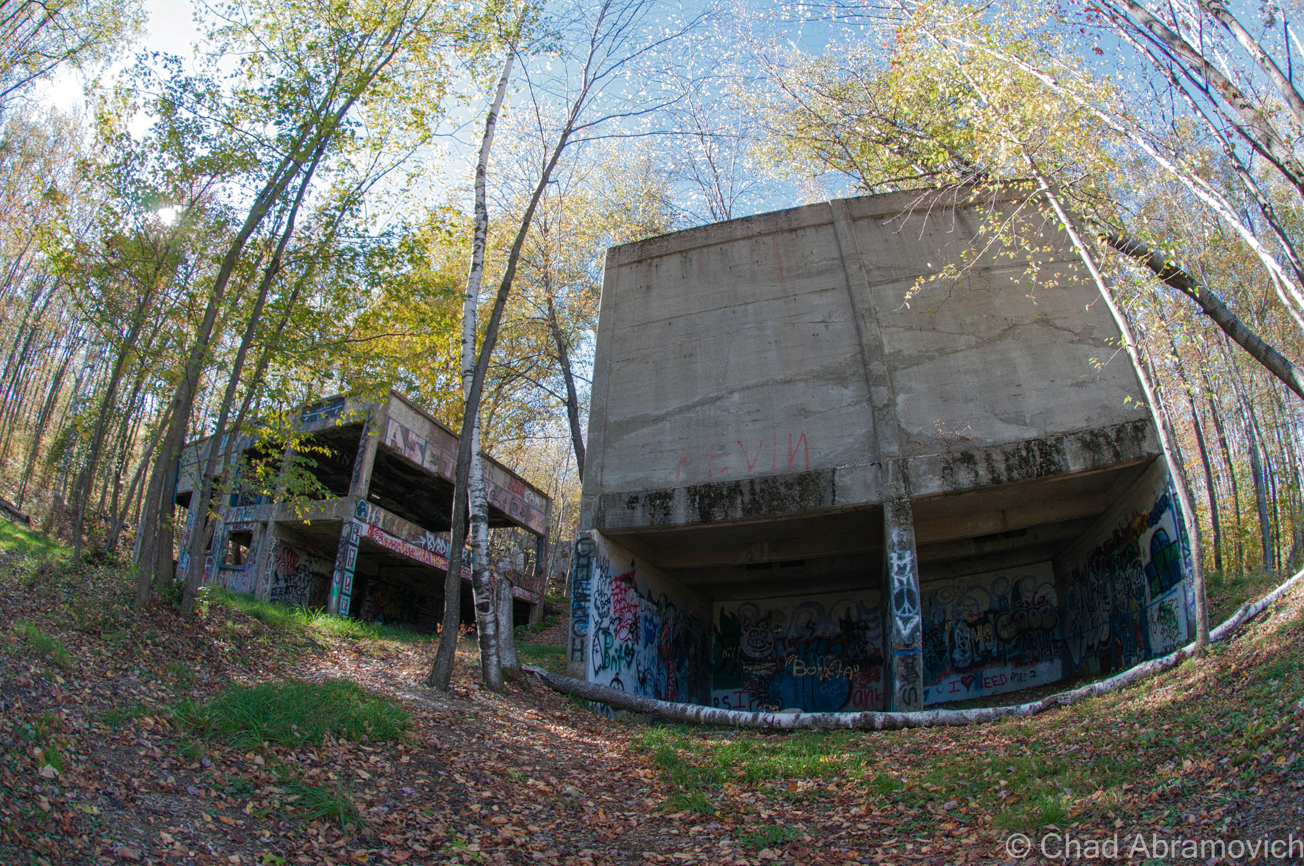
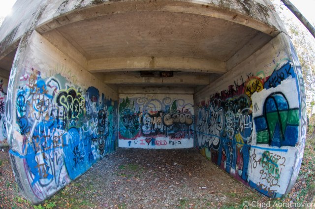
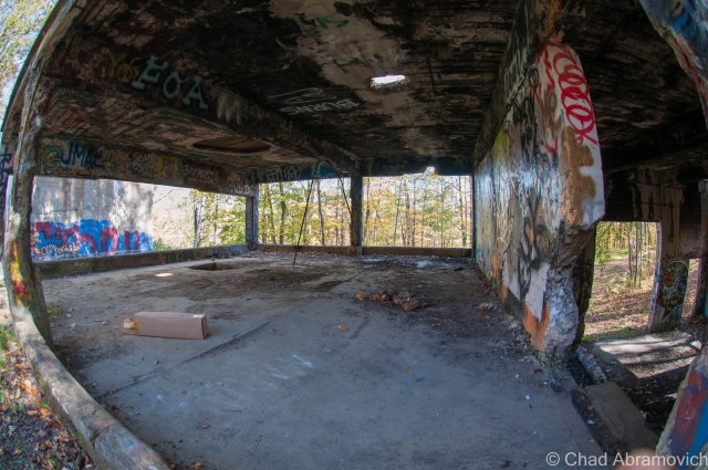
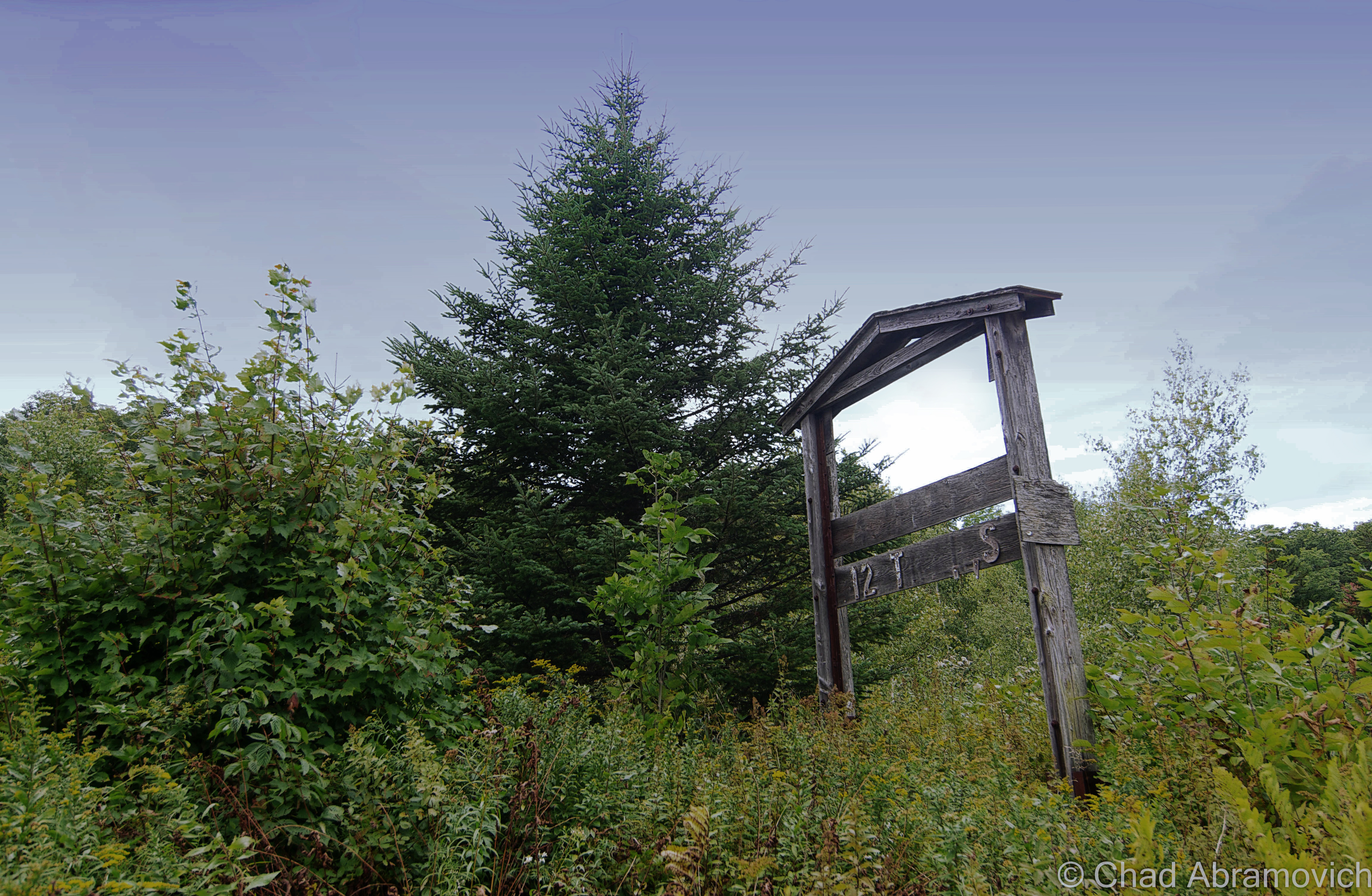
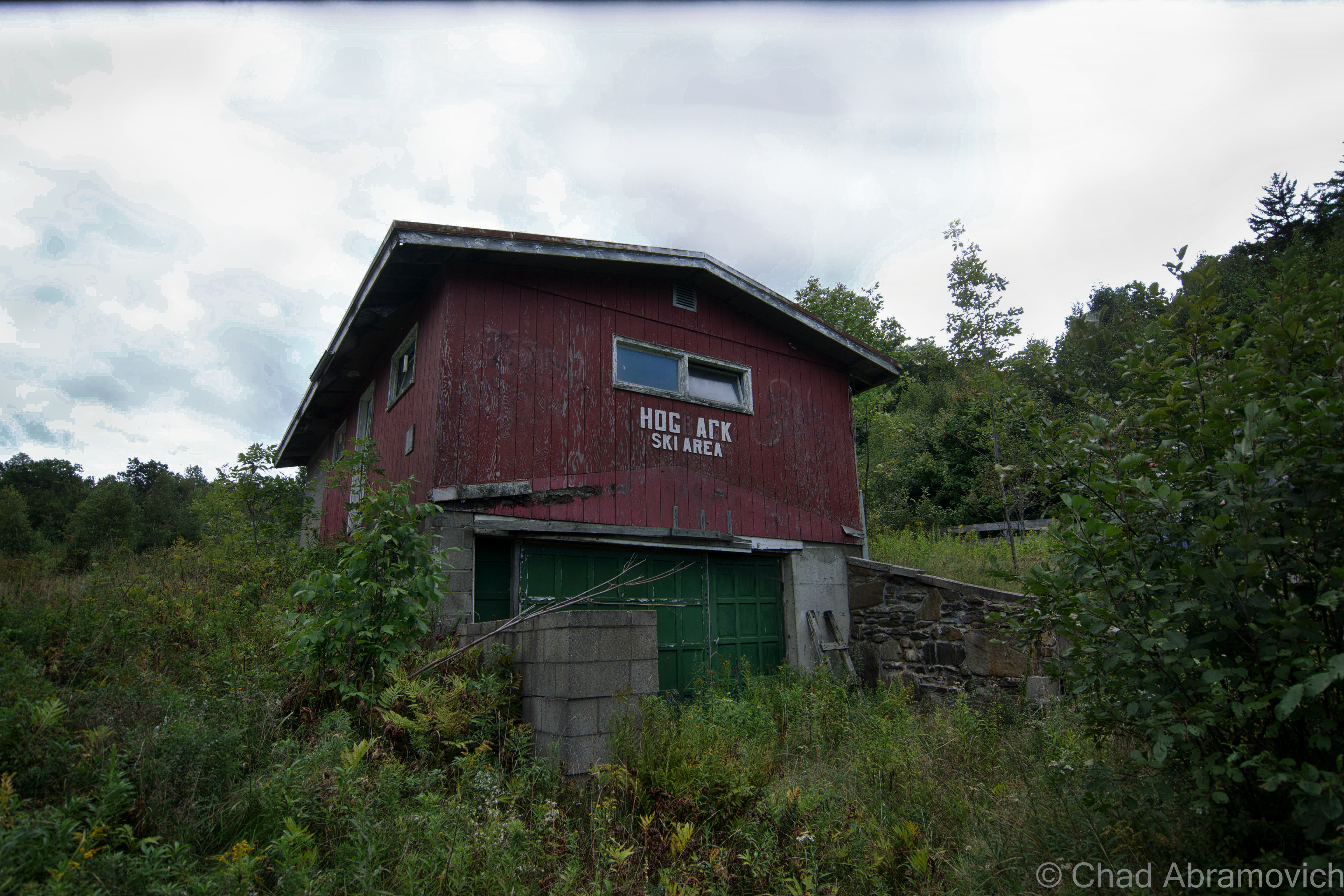
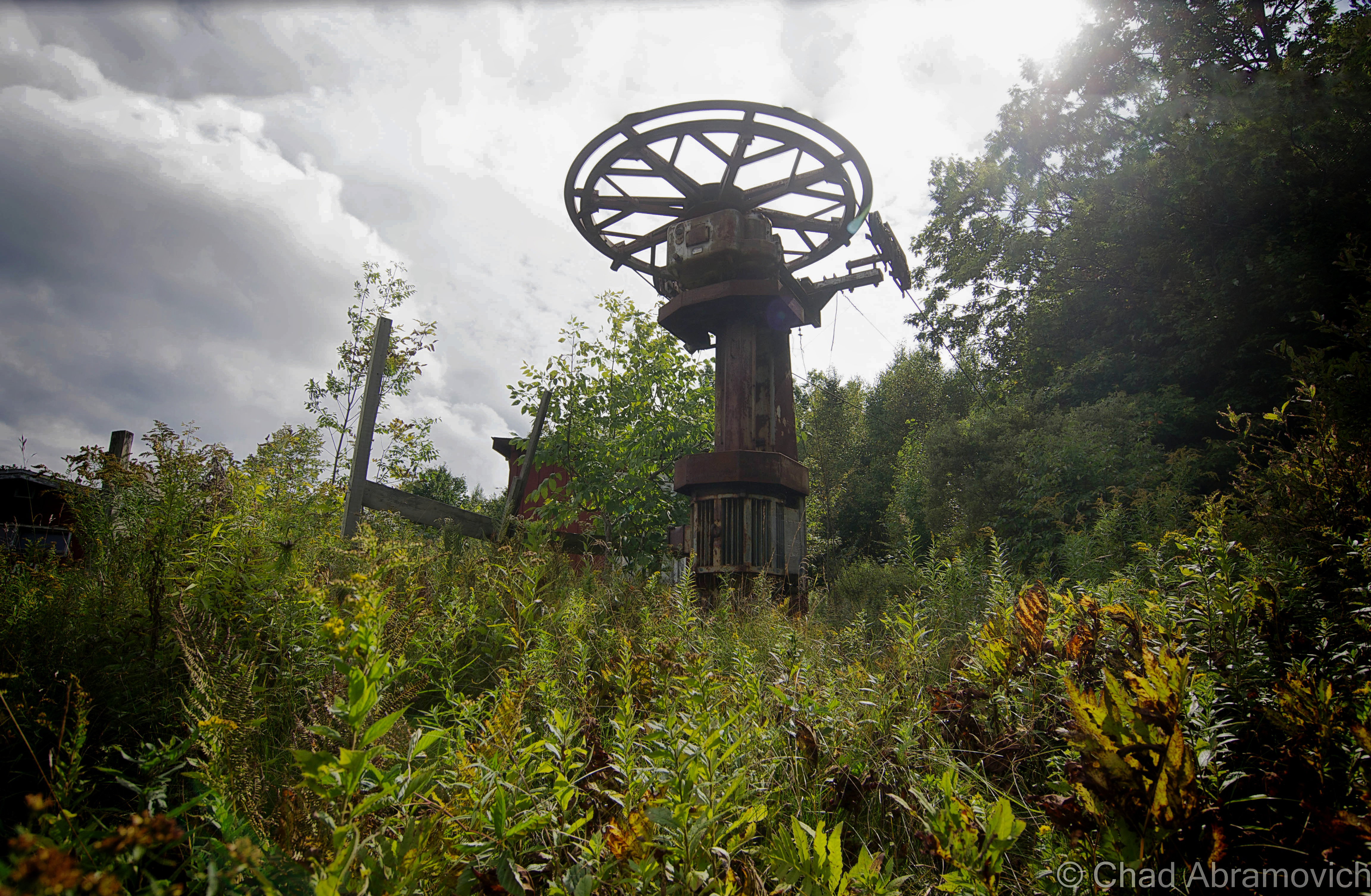
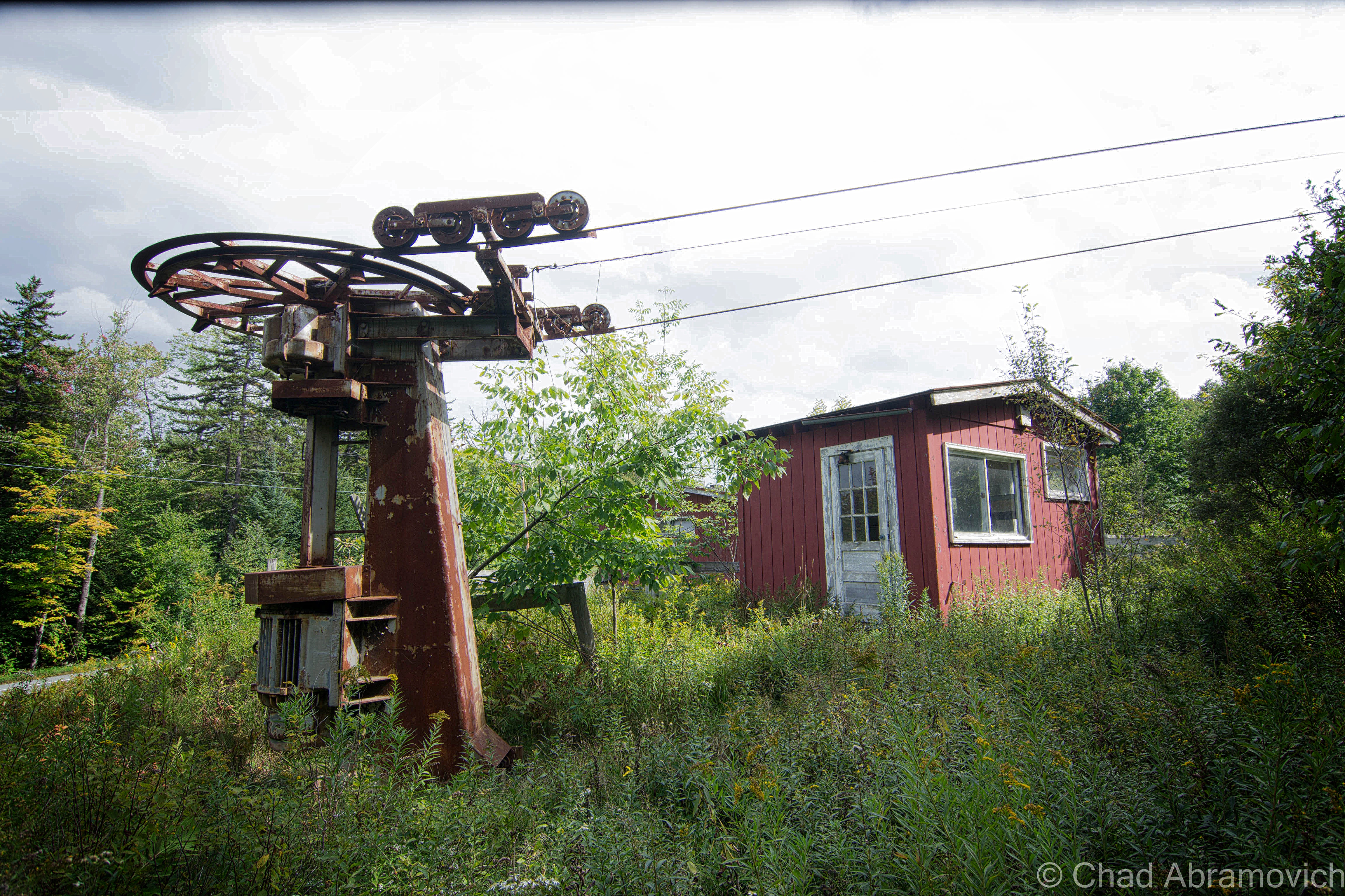
Hogback was one of the longest lasting family owned traditional ski resorts in the state, and arguably is one of the best lost ski areas in Vermont to explore, though you’d probably guess either of these things while driving by the few diminutive red buildings sitting in tangled underbrush along a slight rise above the wide shoulder of route 9. You’d probably never guess the property was even a ski hill unless you were able to catch the white lettering affixed to the former first aid building that reads “Hog ark Ski Area”, which in all honestly would be a memorable name for a functioning ski hill.

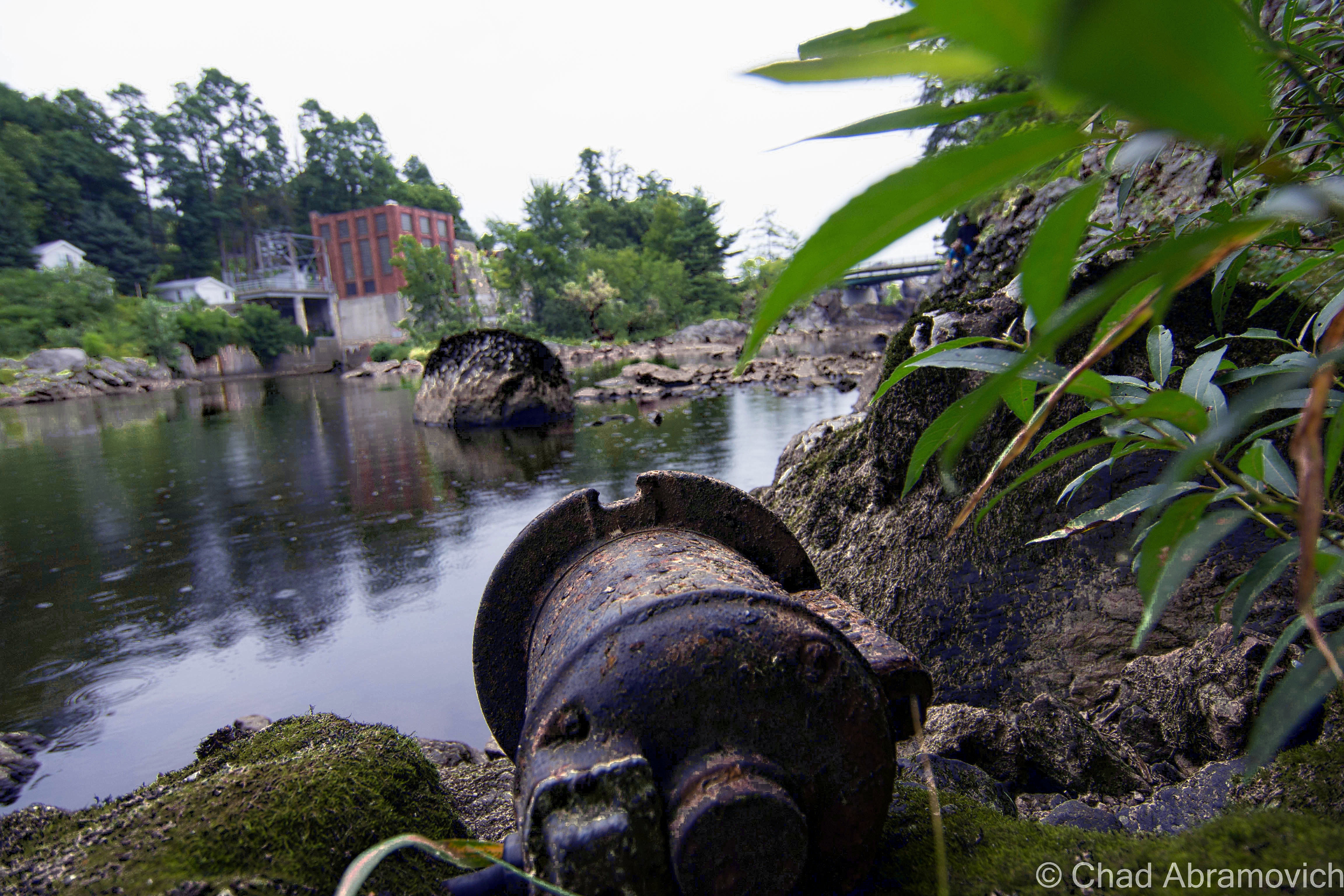
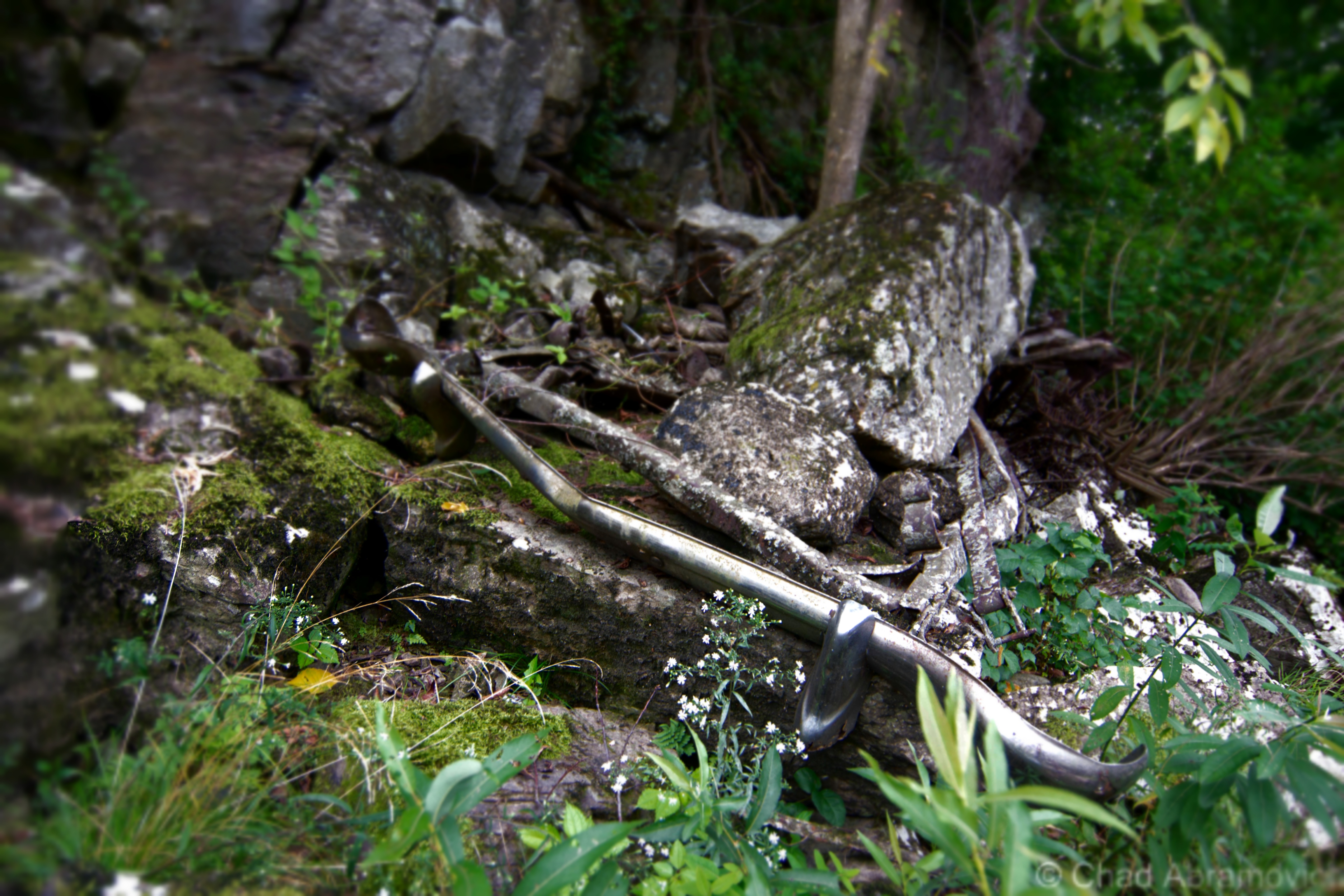
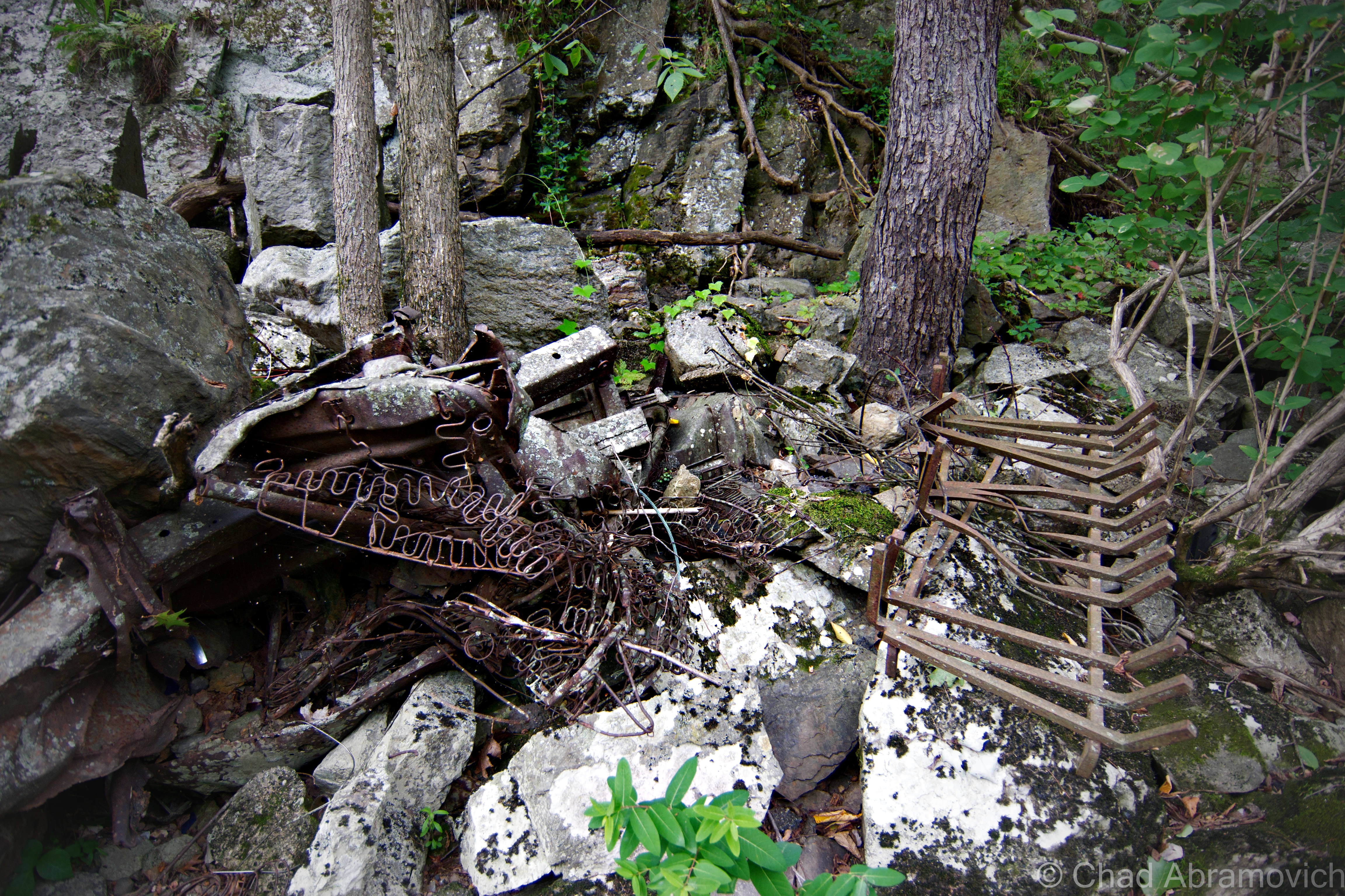
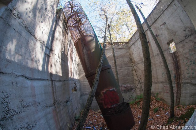
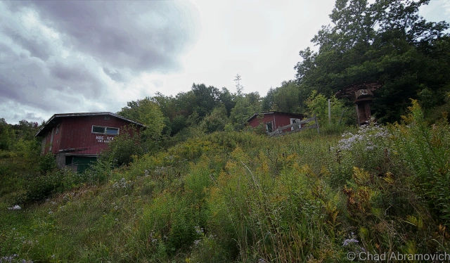
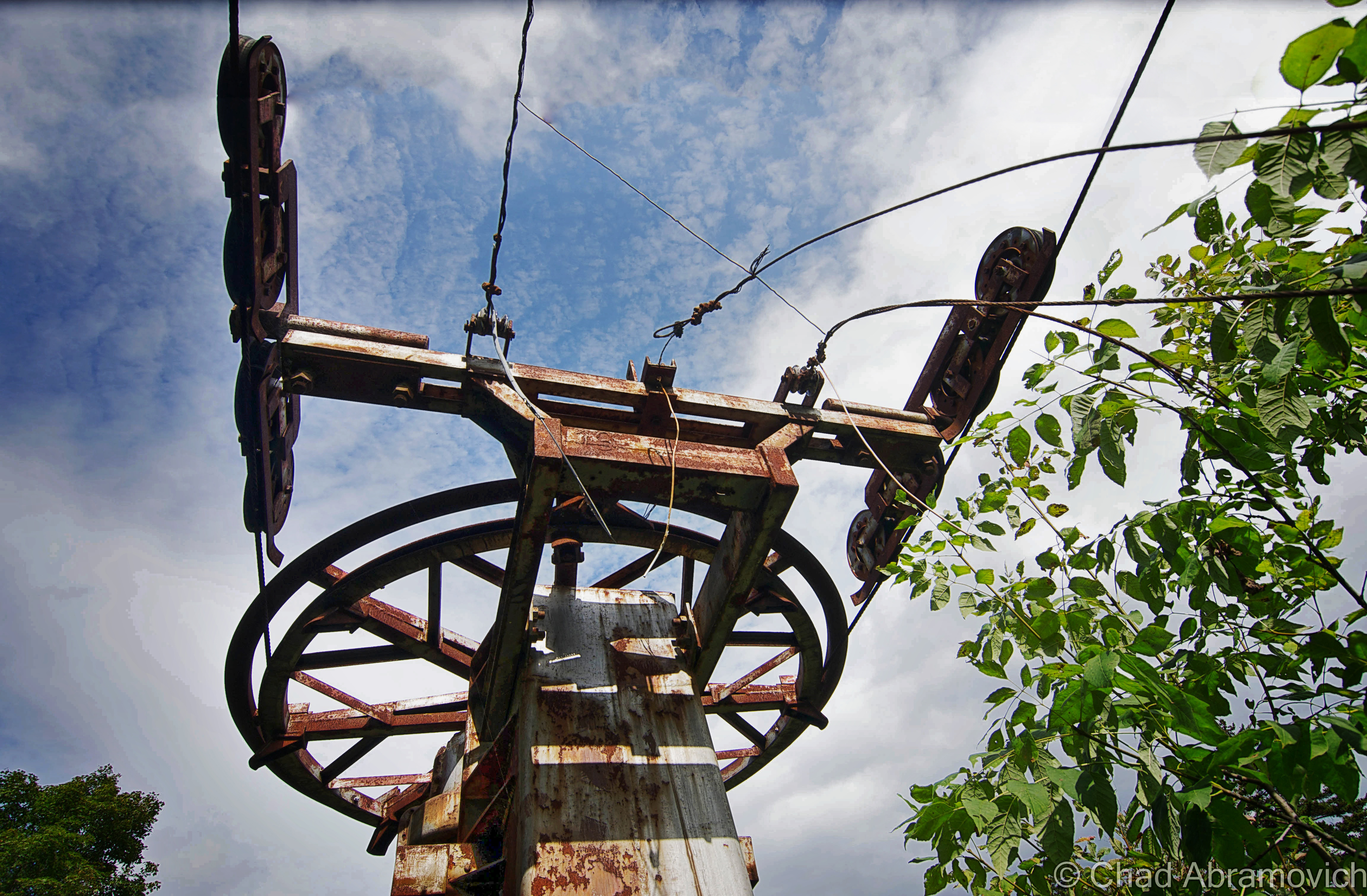
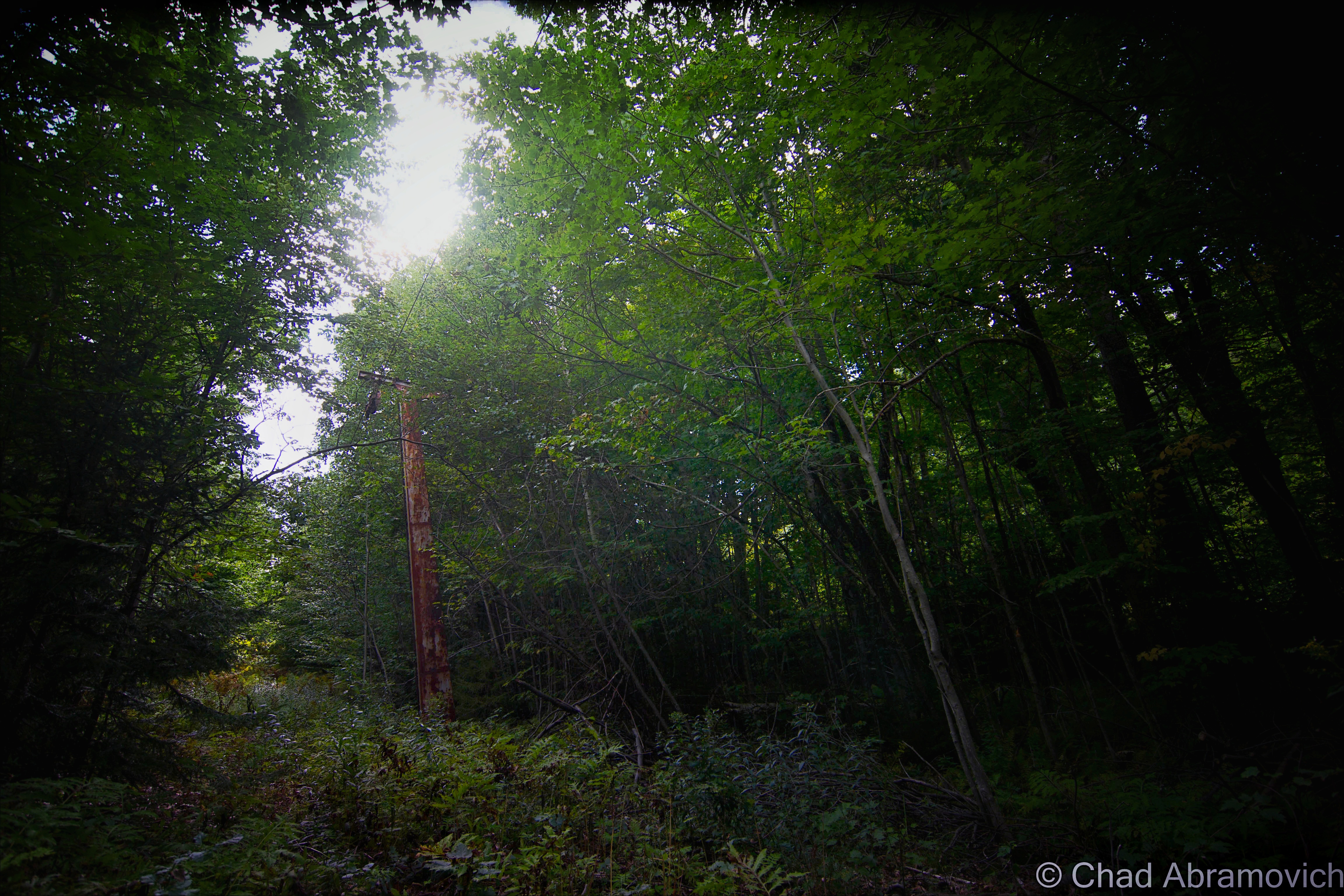
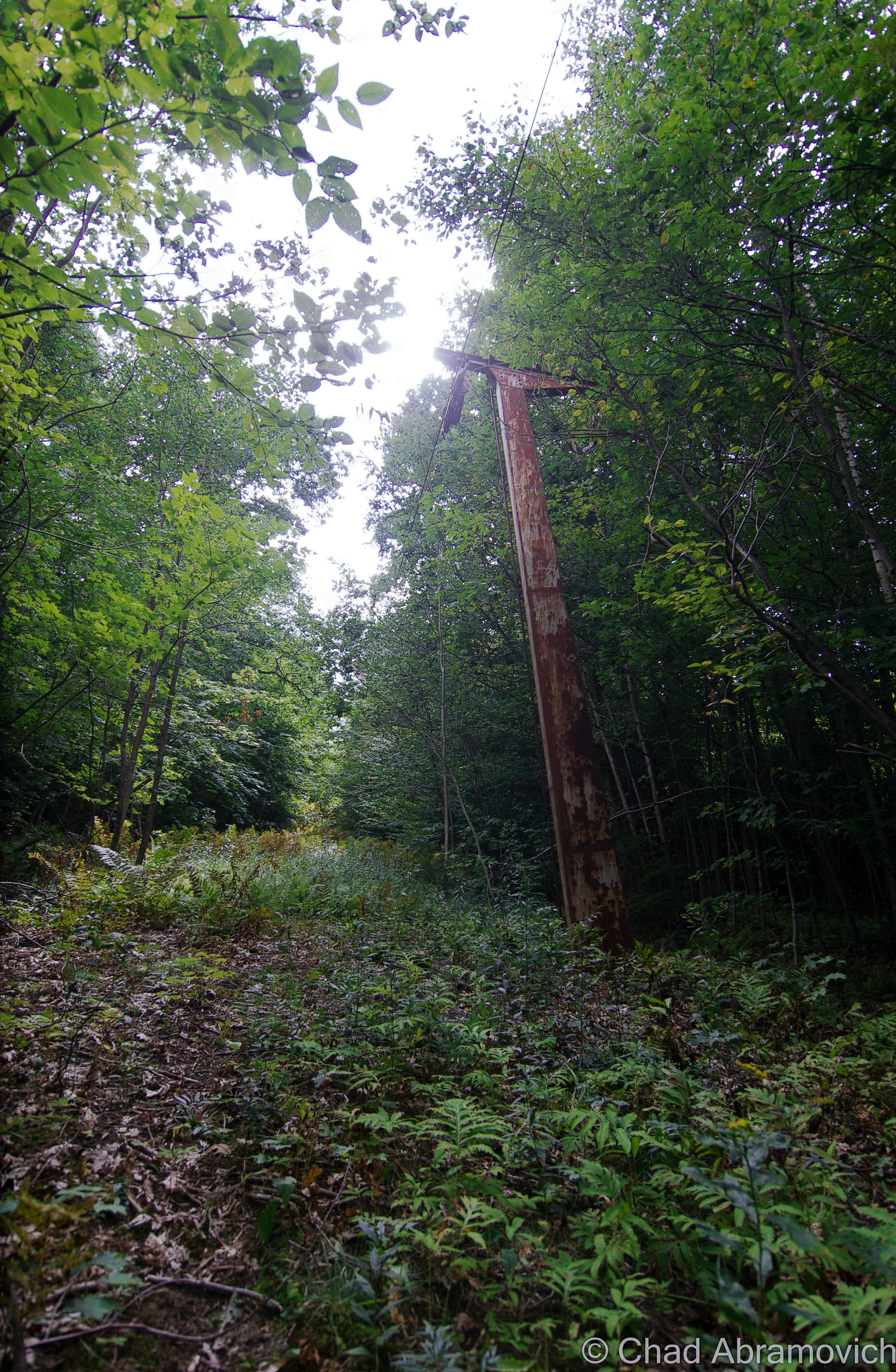
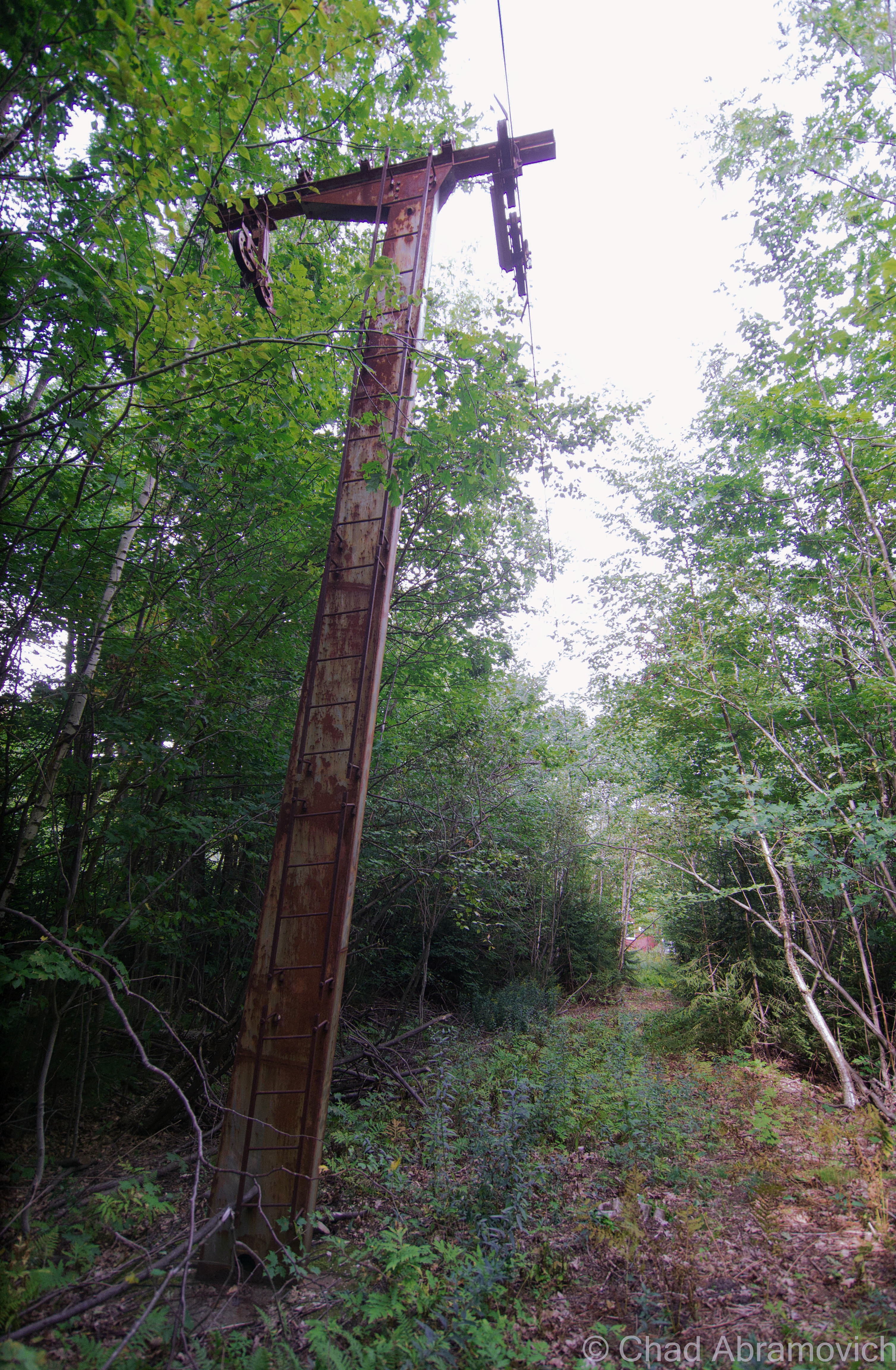
I decided to walk down from the overlook and have a look around at the property. Good thing I wore jeans – the land was wild with tangled undergrowth, and most likely, ticks. Having been bitten by one a month ago, I didn’t want to go through that debacle again. A few old buildings, the rusted bones of an old lift line and a squint-to-make-out overgrown ski trail could still be traced.

Vermont is the land of skiing (and snowboarding) and our pioneering ski hills ranged from extremely plain rope tow affairs to more detailed mom and pop establishments.

If you’re a New Englander, I’d say we’re pretty lucky to have a great site like the New England Lost Ski Area Project. Between that and the book Lost Ski Areas of Southern Vermont by Jeremy K. Davis, I got a startling impression of how many ski areas we once had just in the lower part of Vermont, and how many of them have been, well, lost.

Hogback Mountain itself seemed to be something special. The ski area warranted a pretty long chapter in Davis’s book and a long entry on NELSAP – considering other areas had merely a few sentences. It has a lot of history, so much I had to condense it a bit for the sake of keeping people reading this blog post.

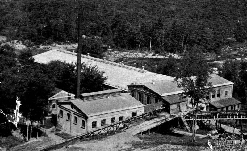
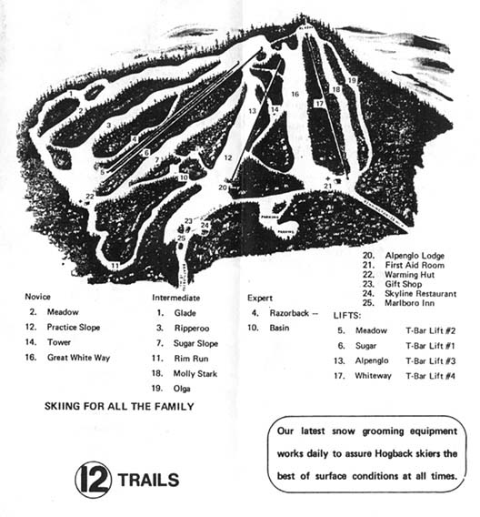
The truth seemed to be that Hogback was envisioned by a community of people who loved skiing, and the consequences were real. Hogback opened for the 1946-47 ski season on prime real estate owned by Harold White, and was operated by the Hogback Mountain Ski Lift Company out of Brattleboro, as well as several of the families who owned the various businesses along route 9, like the White’s who owned the gift shop, the rental shop, the Marlboro Inn and other rental properties. The Douglass’s who were involved with the ski shop, and the Hamelton’s who were involved with the skyline restaurant.

It featured a Constam T-Bar which could move 900 skiers an hour and was the highest capacity lift in the country at the time. Old brochures and trail maps promote the ski hill’s location in Vermont’s “snow belt”, a high annual snowfall area of the Green Mountains which at the time, received an average of 120 inches. The Vermont winters of today are a bit more disparate.

Hogback’s highest elevation was about 2,400 feet (the base area being at around 1,900), which helped preserve the natural snowfall much better than lower area ski hills, which made it so beloved. I observed some older trail maps, and discovered that Hogback had a unique layout. You’d begin your day along route 9 where a hotel, gift shop and Skyline Restaurant were, and ride a rope tow to the practice slope, but intermediate or expert level skiers would have to transport over to a different face of the mountain to access the main T-Bar and more advanced trails.

hogbacktm1
A trail map from the 1970s -Hogback Mountain had 12 trails to ride on. To give you an idea of the weird layout and a wayfinding point: number 21 is the first aid building, and below it is Route 9. The first aid building is abandoned and still visible from the road today. That is also where the practice slopes/beginners area was. The more advanced trails were over on another side of the mountain, where numbers 3, 4 and 6 are.

Over the years, the laid back ski hill caught enough popularity from a top notch ski school, excellent snowfall and a gorgeous mountain where skiers would admire spruce trees crusted in snow. In the 50s, it started to expand, and would continue that momentum through the 70s. More trails were cut down the slopes and made easier accessible by a Pomalift and the addition of 4 more Doppelmayr T-bars. There was also a Quonset Hut brought to the property that served as a ski-in snack hut.

Seriously, this place was a big deal. A lot of the history or accounts I read about the mountain was that plenty of southern Vermont kids learned to ski here. It also helped develop a local interest in ski races and became home to the Southern Vermont Racing Team. If a nearby community, like Brattleboro, had an outing club, they probably went to Hogback. The mountain developed a pretty enthusiastically devoted fanbase. The ski school changed instructors a few times over the decades, each new presence contributing to it in their own way.

One of my favorite images I found of Hogback. Love the front of those old cars parked along Route 9, with equipped skiers ready to ride. The hill was literally along the roadside. | Photo: UVM Landscape Change Program.
One of my favorite images I found of Hogback. Love the front of those old cars parked along Route 9, with equipped skiers ready to ride. The trails were literally along the roadside. | Photo: UVM Landscape Change Program.
People on skies at Hogback, circa 1953. I read stories about how wooden shacks were built around the property and used as warming huts, with pot belly stoves inside burning wood continuously. There were signs nearby warning skiers not to get too close. Several learned the hard way when the back of their nylon packs had melted off. | Photo: UVM Landscape Change Program
People on skies at Hogback, circa 1953. I read stories about how wooden shacks were built around the property and used as warming huts, with pot belly stoves inside burning wood continuously. There were signs posted nearby warning skiers not to get too close because of the heat. Several learned the hard way when the back of their nylon packs had melted off. | Photo: UVM Landscape Change Program
Skiers getting on a T-Bar, circa 1956. | Photo UVM Landscape Change Project.
Skiers waiting in line. Sometime vaguely between 1930-1950. | Photo: UVM Landscape Change Program
T-Bar lift, circa 1948. | Photo: UVM Landscape Change Program.

But towards the 1980s, snowfall began to change to a lack of snowfall. Between not enough natural snow to ski on, rising costs of operation and increasing competition from bigger resorts that were becoming more common on the scene in Vermont mountains, the small mom and pop ski hill eventually couldn’t compete. Hogback’s story is similar to most of Vermont’s lost ski areas. Not being able to compete or stay consistent, most of them became fading ghosts.

Abandoned ski hills are interesting real estate. What do you do with them? Some have subsumed away in the caprices of nature and others re-opened or became private operations. In Hogback’s case, the Vermont Land Trust and a group of adamant people worked pretty tirelessly over the years to secure the funds to purchase and secure the land to save it from becoming a condominium development with a marketed quintessential nature-esque type of name. The purchased acreage was then transferred over to the town of Marlboro, and the cool Hogback Mountain Conservation Area was the result. It’s now glorious protected land, with an abandoned ski hill in the middle that Vermonters can enjoy.

Some of the old ski trails are still maintained and pruned, so hikers, snowshoers and cross-country skiers can still enjoy them. Though, for me anyways, I found that finding those trails was a bit of a challenge.

To my delight and surprise combination, if you bushwhack through some waist-high tangle weeds and growth, you can still find some of the old ski trails, which were still hikable! Well, it’s subjective I guess, but I thought it was achievable. Using the linear rusted cables of the former chairlift as wayfinding points, I decided a short early autumn hike was a good idea. The trail oddly cleared out the farther up I climbed, until both the trail and the lift sort of ended in a blissful and fragrant silence. I was a little bummed I didn’t find an old chairlift or more paraphernalia. If I had gone up farther, I would have eventually stumbled upon the Mount Olga fire tower, which I’m told had splendid far reaching views. You can get there far easier than scrambling up Hogback Mountain, by hiking over via Molly Stark State Park. 

My list of places to visit in Vermont alone is so long, it’s hard to cross stuff off of. I’ll get up there one day.

dsc_0434_pe dsc_0437_pe dsc_0439_pe dsc_0444_pe dsc_0445_pe dsc_0447_pe dsc_0450_pe dsc_0453_pe dsc_0459_pe dsc_0462_pe dsc_0466_pe dsc_0468_pe dsc_0470_pe

There were still old ski poles left behind in the first aid building

—————————————————————————————————————————————–

To all of my fans and supporters, I am truly grateful and humbled by all of the support and donations through out the years that have kept Obscure Vermont up and running.

As you all know I spend countless hours researching, writing, and traveling to produce and sustain this blog. Obscure Vermont is funded entirely on generous donations that you the wonderful viewers and supporters have made. Expenses range from internet fees to host the blog, to investing in research materials, to traveling expenses. Also, donations help keep me current with my photography gear, computer, and computer software so that I can deliver the best quality possible. Seriously, even the small cost equivalent to a gas station cup of coffee would help greatly! Especially now, as my camera is in need of repairs and I can’t afford the bill, which is distressing me greatly.

If you value, appreciate, and enjoy reading about my adventures please consider making a donation to my new Gofundme account or Paypal. Any donation would not only be greatly appreciated and help keep this blog going, it would also keep me doing what I love. Thank you!

Donate Button with Credit Cards

Gofundme: https://www.gofundme.com/b5jp97d4


The Vermont Character: Coffin Windows

One of my favorite pieces of Obscure Vermont is a mixture of architectural vernacular, and good old fashioned Yankee Ingenuity.

Do you see the diagonally tilted window placed in the gable end of this old farmhouse with its long edge parallel to the roof? A lot of people, Vermonters or flatlanders, seem to be flummoxed about these peculiarly slanted windows. That’s because their orientational existence isn’t found in any other states (though someone did tell me that they think they saw one somewhere in New Hampshire not too long ago.) To add a bit more rapturous froth to the isolated mystery, our Vermont parlance labels them “coffin windows”, or sometimes “witch windows”, depending on who you are I guess. Growing up, my mother would always point them out as “coffin windows” whenever we would take a trip out of suburban Chittenden County to more rural parts of the state, where older structures far outnumbered the new. I wasn’t introduced to “witch windows” until much later.

The etymology behind the monikers vary, and can’t really be traced back to a materialized point of origin.

Going alphabetically – it’s said these are called coffin windows because if a family member died upstairs, it was far easier to maneuver the needed coffin out the window and slide it down the roof as opposed to figuring out just how to haul it down a steep and narrow Vermont farmhouse staircase. And trust me, some of them are very steep and narrow to a point of over-cautiousness when walking up or down one – enough for me to sympathize with anyone who would groan at the prospect of dragging anything up or down them.

The name witch window gets a bit more on the superstitious side. It’s said that an old belief was that a witch couldn’t enter your dwelling through a crooked window or opening. A similar superstition that comes to mind is how the ancient Chinese thought bad spirits traveled in straight lines, so their architecture took on steeply peaked rooflines.

I know old Vermonters were a superstitious bunch. Our collective state history and folklore include such grim things as incriminating real people accused of Vampirism, or desecrating the graves of dead people accused of postmortem vampirism (our most famous Vampire execution was a man named Corwin, whose remains still loam underneath Woodstock’s boat shaped town green).

But witches? There isn’t much known on how scared Vermonters were of witches, leaving this as intriguing speculation. However, I was able to dig up a small number of succinct accounts in old state newspapers around the late 1700s and early 1800s of various Vermonters who locals suspected were witches, but in reality were probably nothing more than eccentrics living in a more narrow-minded time. One article amusingly reported that a Stowe woman was blamed for making several farmers’ milk cows run dry.

A more practical theory and probably the most likely of the three, was that these windows were a creative solution to let light into the cramped spaces upstairs. Gables didn’t often leave rooms for traditional sized windows and poor farmers didn’t want to spend the money on drafty dormers or getting a custom window made – which was a costly purchase many families couldn’t afford. They also enabled fresh air and ventilation to keep the house inhabitable. Though there are far more scolding environments than Vermont, our summers do get pretty humid, and the upper floors of an old house easily turn into ovens. 

Further down the line, these windows adopted yet another sobriquet with less dour and more civic pride; Vermont Windows. Though I haven’t heard that term nearly as much as the afore-referenced other two. 

In a world that loves things to fall into human-made symmetry, who knew that a window installed at a tilt could conjure up so many declaratory ideologies.

It seems that these windows have a bit of cool fanfare behind them, apart from your blogger. Some cool individual even made an Instagram account dedicated to them!

Route 100 in South Duxbury
Found one in this abandoned farmhouse I was exploring.
East Calais
Calais
Calais
South Woodbury village
Peacham
Turkey Hill in Northfield.
Warren village
Warren Village
Cornwall
DOUBLE coffin/witch windows in Stowe! I guess these folks didn’t want to take any chances just in case a pesky witch decided to curse them.

Any of you folks know of a coffin window near you? Let me know! I love road tripping around Vermont, and I always make excuses to shunpike somewhere!

—————————————————————————————————————————————–

To all of my fans and supporters, I am truly grateful and humbled by all of the support and donations throughout the years that have kept Obscure Vermont up and running.

As you all know I spend countless hours researching, writing, and traveling to produce and sustain this blog. Obscure Vermont is funded entirely on generous donations that you the wonderful viewers and supporters have made. Expenses range from internet fees to host the blog, to investing in research materials, to traveling expenses. Also, donations help keep me current with my photography gear, computer, and computer software so that I can deliver the best quality possible. Seriously, even the small cost equivalent to a gas station cup of coffee would help greatly!

If you value, appreciate, and enjoy reading about my adventures please consider making a donation to my Paypal. Any donation would not only be greatly appreciated and help keep this blog going, it would also keep me doing what I love. Thank you!

Donate Button with Credit Cards

Gofundme: https://www.gofundme.com/b5jp97d4


Milton Mysteries: The Tunnel Underneath Main Street

This old postcard may be one of my favorite finds from the Milton archives. Published by Raymond A. Coburn, who owned the pictured general store in Milton from 1908 until the flood of 1927. This image of “downtown Milton” depicted a cartoonish almost satirical image of what town had the possibility to be like in the future. That vision included blimp taxi service to South Hero, which I still think would be sort of cool. Today’s Milton of the future has a CCTA bus line. | photo: Milton Historical Society.  

My thoughts on Vermont weirdness often drift back to Milton, my former hometown. I suppose this is where I would further enhance that sentence with an explanation, but to be honest, I’m having trouble coming up with an angle on this. It’s where I grew up, and something about spending a third of my life there has just tattooed it into my framework. It’s where my love of the weird and the offbeat began from inside a quiet suburban bedroom, and began to proliferate outwards – which would become one of my most distinguished aspects of my personality, and why this blog now exists.

I often tote the Milton Creamery as the first abandoned building I've ever explored and became fond of, but more accurately, it was this ramshackle barn on the North Road I used to pass when I'd ride the school bus home. As a kid, I awarded it the moniker;
I often tout the Milton Creamery as the first abandoned building I’ve ever explored and became fond of, but more accurately, the first forsaken place I would ever lay eyes on was this ramshackle barn on the North Road I used to pass when I’d ride the school bus home. As a kid, I awarded it the moniker; “the broken barn”, which wasn’t all that creative but oh well, at least it was memorable. My mom was even cool enough to drive a little 6 year old me there a few times so I could explore it. Today, the faded relic is barely recognizable as the forest has almost consumed it. This was taken circa 1994, and is a scanned photograph.

As I grew older, I let my burning curiosity get the best of me, and began writing down all the urban legends and stories from my childhood, and all the accounts told to me over the years. This was a ritual I began to love, because I was quickly finding out that Milton was a fascinatingly storied town!

Its geographical area is unassumingly large, ranking 10th largest in land area and 8th in population (10,352 bodies at the 2010 census). All of that space is a perfect for hemming in obscure things and historical oddities. In the 1920s, aviation enthusiast and innovative inventor Paul Schill built an airport in town, where Sears and Ace Hardware are today (which accounts for the pancake flat plot of land along Route 7). But his goal of putting Milton on the map as an aviation manufacturer hot spot died in the beginnings of the great depression after he declared bankruptcy. In the later half of the 20th century, we were one of the premier racing towns in the northeast, with the Catamount Stadium (something I’d love to write about in great detail) and a drag strip drawing enthusiasts from around the region. These things have also became faded ghosts with the changing of the times.

Over the years, Milton would be a place where I would begin to shake hands with a lot of ghosts. Some were metaphorical; conjured from inflicting wounds laid upon to me. I began learning a lot about my Aspergers diagnosis in this town and still remember my lonesome youth rolling and stumbling, figuring out how I processed information in different ways from the rest, and how I often felt powerless because I didn’t feel like I understood the world around me, learning the rules out with the wolves.

But some of these ghosts were real. A former friend once told me about how their Bert’s Mobile Home trailer was haunted by the ghost of a little girl, who particularly liked a long narrow hallway connecting the bedrooms behind the living room. Though I’ve spent quite a bit of time there in my past life, I never had a run in with her. But I do recall the hallway always being dark and creepy, even during the day, which is a good breading ground for spook stories. When I asked the family about the girl, it became more complex and amorphous like these stories always tend to do; there were no records of any young girls growing up or dying there, making this story a weird mystery. But, they somehow knew she was there.

There is said to be a house on Main Street where things literally go bump in the night, perhaps because it used to be a funeral parlor in the last century. Weird lights and objects in the sky have been reported around 900 foot Cobble Hill for a few decades, and local lore tells of a haunted island in man-made Lake Arrowhead where a young woman was murdered by her jealous stricken husband in the late 30s, when he became enraged after the men of town kept admiring her. And, I’ll always remember this arbitrary point of non-trivia about Hobbs Road. Though the paved thoroughfare was named after a farming family, my friend once joked to me as he was reading the directions I wrote down so he could find my house; “I noticed that your neighborhood was off Hobbs Road…did you know that Hobbs is an old name for the devil?”

The more curious I became, the more I began to take comfort in the quiet company of weirdness and lore. Some mysteries I would have the pleasure of investigating, others still remain lost somewhere in the haze. Either way, both sets of ghosts would successfully haunt me for years to come.

Underneath The Ground

One of the most impressionable stories from my childhood told of a clandestine tunnel that started in the basement of the Joseph Clark mansion and ran underneath several old homes on Milton’s Main Street.

The stately Joseph Clark mansion, perched on a slight rise above Route 7, used to be the town offices and library back in the 1990s, which was the time when I picked up on the story. According to some, one of the house’s long dead builders is still there, and may be responsible for the next part of the story.

Kids in the library used to do what kids do best, and venture into places they weren’t supposed to. One of those places was the tunnel. But some would come running back up the stairs, visibly shaken, and tell the librarian that they were chased away by a man in the tunnel they thought was a security guard, whose presence was announced by the sound of heavy footsteps approaching them and then a glimpse of his tall dark form. But, the librarians would be confused and explain that the library had no security guard.

Unfortunately, that was where the story went cold. Was there really a tunnel underneath Main Street, connecting many of the town’s oldest homes together? If so, what was it used for? Popular theories guesstimate that it was constructed for use in the underground railroad.

Lorinda Henry of the Milton Historical Society was kind enough to sit down with me and help me in my search for answers. Meeting in the Milton Museum, which is pretty much the town attic that sits in an old church, we dug through countless unlabeled binders and boxes, but sadly, any information containing the tunnel wasn’t in their archives, or had long been lost. But the builder of the Clark mansion, however, was well documented.

The Joseph Clark Mansion
The Joseph Clark Mansion | Photo: UVM Landscape Change Program

After Milton’s official chartering in 1763, settlement was lackluster for the next 30 years. West Milton on the lower Lamoille banks, became the first part of town to be developed. A few miles up the river was a part of town that was known as Milton Falls, which would be the area around present day Main Street. In 1789, Elisha Ashley would survey the first east-west road in the Milton Falls section of town, by running a straight line from the Westford/East Road intersection, to a stump on the Lamoille River. Noah Smith, one of Vermont’s first lawyers, owned most of the land around what would become Main Street and Milton Village.

Joseph Clark was one of the earliest settlers in town, and his business endeavors made him both one of the wealthiest and most influential residents in Milton. He came to Milton in 1816, a year known by Vermonters as eighteen hundred and froze to death, because of the unseasonably frequent snow and frosts that caused widespread crop failure across the northeast. It’s no surprise that some superstitious Vermonters saw this as the coming of the end of the world.

But while the crops were failing, Clark and his partner Joseph Boardman saw opportunity in the rich pine forests that covered most of Milton, and hired crews to harvest the fine timber. The logs were floated up Lake Champlain to Montreal, before they were shipped to England, many to become used by the Royal navy. By 1823, he would purchase a sawmill in West Milton to process the raw timber. But by 1830, woodlands were replaced by agricultural land, and Clark decided to invest in other opportunities. He would build a gristmill in Milton Falls, then move into the brick mansion on Main Street that now bears his name. Later, he would build himself a two story brick office building where Main Street meets River Street, today’s Route 7. Clark’s move and investment in Milton Falls would lure more people and business endeavors there, and make that the new hub of town.

Joseph Clark's Gristmill, where present day Ice House Road runs over.
Joseph Clark’s Gristmill, where present day Ice House Road runs over. | Photo: UVM Landscape Change Program

Here, the Lamoille River and gravity worked together to form about 5 waterfalls in a few miles of one another constricted in a rocky gorge, before relaxing at West Milton. These falls were ogled and soon sought after for industry. Some however also envisioned bravado and a way to kill boredom. In the 1800s, a growing number of young people in the northeast were jumping in barrels and going over any waterfalls they could find, which would achieve both getting mentioned in the newspaper and sometimes death. I once heard many years ago that around that time, a local boy and self-described dare-devil went over Clark’s Falls in a barrel. But to my huge disappointment, I couldn’t find any verification or information on this man or his leap over the falls. I liked that anecdote enough to include it in this entry though.

Railroads were rapidly spreading their steel arteries across the United States, bringing people, opportunity and growth with them, and because these things were vital for business exploits, this caught Clark’s attention. Partnering with John Smith of the Central Vermont Railroad, they worked to get some tracks built through Milton. In 1845, Milton had a rail line and accompanying train station, and that benefited the town greatly. After the civil war, the railroad brought vitality to the town’s burgeoning summer tourism industry and industrial mainstays like the former Creamery, a building which has shaped my love of exploring and photography.

Clark would continue to remain active in town affairs until his death in 1879. The house was passed down to family members until 1916, when Joseph’s granddaughter, Kate, deeded the house to the town of Milton to use as the town offices, and remained so until 1994 when it was reverted back to a private residence.

Lorinda speculated that the former gristmill behind his mansion could have warranted the construction of a tunnel, which would have sat where present day Ice House Road is. The house was built on a slight ledge, which would have made the tunnel a more convenient way to travel from one place to another, especially in the grueling Vermont winters. But there was no way to know for sure.

The mill and most of the development near the river were washed away during the flood of 1927, making investigations almost impossible.

It was later told to me that someone knew of a “thick iron door” found in the basement of Joseph Clark’s former office building on the corner of Route 7 and Main. This was one of the few buildings on River Street to survive the flood of 1927, so that claim seemed pretty credible to me. (But if it were built at a later date, I would be really curious about that mystery as well)

Joseph Clark's Office Building on the corner of RIver St (Route 7) and Main. Milton denizens today may recall it by it's former reincarnation, as Irish Annie's Pub.
Joseph Clark’s Office Building on the corner of River St (Route 7) and Main. Milton denizens today may recall it by its former reincarnation, as Irish Annie’s Pub, which was sort of a hole in the wall affair where the brick facade almost fell into the road a few years ago. | Photo: UVM Landscape Change Program

Geography would aid me here. The building was built into a ledge that forms the beginning of Main Street hill. Right above sits the Clark mansion. This means that a door in the basement wall would have lead to some sort of subterranean chamber, which may have been a tunnel.

The historical society told me of a former resident and her mother who once lived there, and claimed to have seen the iron door themselves. The facts seemed to be finally adding up here, but it seems my request for information was a few years too late. The building has since been sold, and it’s current owner denies the existence of a door firmly and doesn’t want to talk about such things. I attempted to reach out to the previous owners who brought forth the iron door sighting, but they had told the historical society so long ago, that their contact information had since vanished.

The Irish Annie's building (now vacant) - where the supposed iron door is said to be. Main Street is to the right, which runs up the hill. The Clark Mansion sits behind it.
The Irish Annie’s building (now vacant) – where the supposed iron door is said to be. Main Street is to the right, which runs up the hill. The Clark Mansion sits behind it. Photo: Google.

Another suggestion illustrated that the tunnel once ran all the way up the hill to the abandoned creamery on Railroad Street. And sure enough, there is a walled up door in the basement that once did lead to a tunnel. Could this be the proof I was looking for? I did a little digging around (literally), and talked to a former employee. As it turns out, the door did lead to a tunnel, but it wasn’t the tunnel. It ran significantly shorter, just over to the brick building next door which was also owned by the creamery at the time (now converted to a private residence). But that tunnel also had its notoriety. Former creamery employees and older Miltonians wistfully admitted that they used to sneak down and party in that tunnel, those shindigs usually included spirits and cigarettes, while the creamery was in operation and even in the years after it’s closing.

The Creamery Tunnel, sealed off at it's other end.
The creamery tunnel, sealed off at its other end.

The tunnel story seemed to be disappointingly falling apart. Though it was cool to think about – practically, it didn’t make sense. If we stick to the theory of a tunnel running all the way underneath Main Street, why would such a long tunnel need to be constructed? What was it’s purpose? To further deteriorate the story, the stately homes on Main Street were all built around different times, meaning their construction most likely didn’t accommodate the existence of a tunnel. And to prove this, I had spoken with a few Main Street residents who had never even heard the story of the tunnel, but all assured me the only way into their homes were through the front or back doors.

Vicious Waters and Dislocation

It wasn’t until some time later, after this project had been pushed to the back of my to-do list that something came up which immediately pulled it from memory. A Facebook commenter who knew that I was attempting to get to the bottom of this sent me a message and shared a personal account with me. As a kid in 1960s Milton, he used to play with his buddies down near the river, and he recalled seeing a cave like opening set back in the cliffs near the dam. Popular labeling at the time dubbed it as a tunnel. He even remembers his parents admonishing him and telling him not to go near it because it was likely to be dangerous. He never did, but speculated that it may be what I’m looking for. He also said that some of his friends claimed to get inside, but couldn’t recall any more than that. For all we knew, they may have been embellishing the truth.

One gloomy summer afternoon in August, I set out with a few friends to dig around the Lamoille banks, trying to find the telltale opening. That part of town has long been awarded an odd moniker by local youth who call it The Vector, which is a robust sounding name, but I can’t seem to relate it’s actual definition to the rocky gorge spanning from the Route 7 bridge to the bottom of twisting Ritchie Avenue. But the name has proven very successful at sticking into the flypaper of local culture. I grew up knowing that area as The Vector, and still do.

An early stereoscope view of the area known as The Vector, early 1800s, before the dams and industry. The Lamoille River gorge was a wild place. Photo: UVM Landscape Change Program
An early stereoscope view of the area known as The Vector, early 1800s, before the dams and industry. The Lamoille River gorge was a beautiful wild place. Photo: UVM Landscape Change Program
Early explorers on the Lamoille River near Milton Falls, early 1800s. Photo: UVM Landscape Change Program
Early explorers on the Lamoille River near Milton Falls, date unknown. Explorer Samuel De Champlain called the river la Mouette, from all the gulls he saw when he navigated it, but it’s solidified name came from an error years later when an early map maker forgot to cross his t’s. The waterway is the only Lamoille River in the world. Photo: UVM Landscape Change Program
Ritchie Avenue is one of Milton's more impressive thoroughfares. The quiet road follows the pools of the Lamoille River before dropping down a series of ledges offering great views of the Lamoille and the towns rolling hills that stretch out to Lake Champlain. The distracting road was built to accommodate the construction of a pulp mill down in the vector, which once employed over 100 people. A strike in 1925 closed it, and the flood of 1927 destroyed it.
Ritchie Avenue is one of Milton’s more impressive thoroughfares. The quiet road follows the pools of the Lamoille River before switchbacking down a series of ledges yielding great views of the Lamoille and the low profile hills that undulate to the shores of Lake Champlain. The distracting road was built to accommodate the construction of a pulp mill down in the vector in the early 1900s, which once employed over 100 people who all built homes in town, which accounts for why so many houses on upper Cherry Street look similar. A strike in 1925 closed it, and the flood of 1927 destroyed it. Most of the area has been transformed into a kayak launch area and substation for Green Mountain Power, but some of the twisted remains and chunks of brick walls from the old place can still be seen at the bottom of the hill. I used to hang there as a teenager and explore the river’s islands, caves and rapids. | Photo: UVM Landscape Change Program
The incline railroad that carted lumber at the pulp mill, ran up the steep banks and towards where present day Mackey Street is. Years and years ago, someone told me that one of the rods or bolts from the supports could still be seen in those woods today, if you know where to look. But I can't verify this, as I haven't been able to find it.
The incline railroad that carted lumber at the pulp mill, ran up the steep banks and towards where present day Mackey Street is. Years and years ago, someone told me that one of the rods or bolts from the supports could still be seen in those woods today, if you know where to look. But I can’t verify this, as I haven’t been able to find it, which sort of makes this a similar tantalizing mystery like NYC’s Central Park and the famous lost survey bolt from it’s creation. | Photo: UVM Landscape Change Program

While doing our amateur urban archaeology, we found a surprising amount of items along the river banks, in the waters and even stashed in crevices that ran like veins through the crumbling rock ledges. Broken pieces of China plates, old glass bottles, rusted tools and even the remnants of an old truck lay trashed down in the rocky gorge, things that blurred the lines of being considered an artifact or garbage.

I knew this area was hit hard during the flood of 1927 and artifacts, cars and even entire homes were swept up in swollen brown tides down this part of the river, depositing much that still rests below wet rocks and Hemlock trees today. I even was able to dig up old newspaper accounts that were printed when the disaster was happening. One vivid memory was reported by a woman, who watched an entire house be swept down the river, almost entirely intact. She said she was able to look inside a broken window and see someone’s bed that had been turned down, as if the person was just about to turn in for the night.

The flood of 1927 is mentioned frequently in conversation of Vermont history, as the flood completely rearranged Vermont culture and infrastructure, and the after-efforts built much of the state we know today. The UVM Landscape Change Program archives had lots of photos of Milton pre and post flood, which gave me a startling impression of what was lost. This is the former town square, Milton's
The flood of 1927 is mentioned frequently in conversation of Vermont history, as the flood completely rearranged Vermont culture and infrastructure, and the after-efforts built much of the state we know today. The UVM Landscape Change Program archives has lots of photos of Milton pre and post flood, which gave me a startling impression of what was lost. This is the former town square, or “Downtown Milton” (1890). Joseph Clark’s office building can be seen on the immediate right, and was the only building in this photograph to survive the flood and exist into present day Milton. Phelp’s Store, which wasn’t photographed, also still stands underneath modern day red vinyl siding. Today, Route 7 is more or less, built right over this area.
Starting on November 2nd, an estimated four to nine inches of rain drenched Vermont and turned rivers into raging destructive torrents. Because it was late Autumn, the dry ground was unable to absorb the water. Soon, Milton residents watched as the Lamoille River turned River Street into an accurate description of it's name. Photo: UVM Landscape Change Program
Starting on November 2nd, an estimated four to nine inches of rain drenched Vermont and turned rivers into raging destructive torrents. Because it was late Autumn, the dry ground was unable to absorb the water. Soon, Milton residents watched as the Lamoille River turned River Street into an accurate description of it’s name. Photo: UVM Landscape Change Program
Flood waters on River Street in Milton, 1927. Photo: UVM Landscape Change Program
This is one of my favorite photos I was able to dig up, because it awesomely depicts the destructive powers of nature. In this blurry shot, it shows the Star Theater sink and wash away before a crowd of onlookers. Photo: UVM Landscape Change Program
Post flood damage. Photo: UVM Landscape Change Program
By November 5th, it was over, and the post flood damage was phenomenal. Photo: UVM Landscape Change Program
The remodeled town square after the flood, with Joseph Clark's office building and Phelp's store the only surviving buildings. Photo: UVM Landscape Change Program
The remodeled town square after the flood, with Joseph Clark’s office building and Phelp’s store the only surviving buildings. The Gold Medal Flour advertisement on the back of Phelp’s Store survived until the building was renovated years ago, and sadly sided over. Photo: UVM Landscape Change Program
One of more popular tales of Milton lore is of the village underneath Lake Arrowhead. Basically, people claimed that downtown Milton was flooded underneath the lake when it was built, meaning there are a collection of soggy farmhouses at the bottom of the lake. As a kid, I even heard stories of scuba divers diving into the lake and setting foot on the roof of a house. After extensive digging, I was able to find this picture. This shows River Street, or Route 7 north of the bridge, which is now the Lake Arrowhead Causeway. These houses all sat where Route 7 is now.
One of the more popular tales of Milton lore is of the village underneath Lake Arrowhead.Basically, part of old Milton still remains below the lake after the area was submerged. As a kid, a friend’s mom told me that she knew someone who scuba dived down to the bottom and set foot on the roof of one of the old houses, which I thought was incredible. Then I would find this picture, which would offer some clarity to my fascination. This shows River Street north of the falls. The buildings pictured would be all underwater today, near where Route 7 runs along the lake. When plans to flood the area were made known, homes and businesses were moved and the new road would be built atop a raised dirt bed 90 feet high, still refered by old timers as “the fill”. But local lore maintains that some properties that were too damaged by the flood, somehow weren’t hauled off, and remain at the dark soggy bottom today. If there is in fact stuff down at the lake bottom today, I’m sure it would be in pretty rough shape, but with other stories around Vermont of sunken villages, would also be believable.| Photo: UVM Landscape Change Program.
In 1936, The Public Electric Light Company began constructing a dam above Clark's Falls, which would create the 750 acre Lake Arrowhead and provide a source of hydroelectricity. At the time, the Burlington Free Press lauded it as a technological marvel.
In 1936, The Public Electric Light Company began constructing a dam above Clark’s Falls, which would create the 750 acre Lake Arrowhead and provide a source of hydroelectricity. At the time, the Burlington Free Press lauded it as a technological marvel.| Photo: UVM Landscape Change Program
Luman Holcombe, a longtime Milton resident and respected community physician, was the one who suggested the name
Luman Holcombe, a longtime Milton resident and respected community physician, was the one who suggested the name “Arrowhead Mountain Lake” in 1937, because on still days, the reflection of nearby Arrowhead Mountain in the water forms to make an arrowhead. The cluster of trees in the middle of the lake are growing from the allegedly aforementioned haunted island. I also like the boats in the picture. The lake is a relatively dead place now days.| Photo: UVM Landscape Change Program

A better understanding of the flood also gave me a better understanding of the area I was going to explore. Not surprisingly, its popular with people who like to metal detect who are still finding things transplanted from the flood and years onwards, so seeing all of this rubbish down there wasn’t a shocker. But something didn’t quite fit. One odd find was that a certain crevice seemed to be filled with trash – but it was put there by someone. This wasn’t naturally occurring. Someone had been down there at one point, trying to fill it up…

After a while of picking at the pieces and dislocating rocks, we were able to catch a peek deeper into the crevice, which expanded far back into a dark rocky chasm. It was evident that there was, in fact, more to see, and it did extend backwards, but I knew it wasn’t what I was looking for. Granted, the space had long been filled in by dead leaves and garbage, but it seems too narrow for what could be considered a tunnel. No man could seemingly fit back there, without the aid of tools and a great deal of ensuing noise. Either way, I stopped my efforts.

DSC_0878_pe
The collection of items we were able to dig out of the crevice in the cliffs. All of the following photos were taken in the dying days of summer, 2014.

DSC_0874_pe DSC_0884_pe DSC_0886_pe DSC_0887_pe DSC_0891_peDSC_0873I came up empty on August’s exploration, but in October, another lead would unexpectedly manifest itself, and it was promising. Meeting up with childhood friend Zach, I found myself in a location I normally avoid, a hole in the wall bar and pool joint in Essex Junction.

I was there to speak with a friend of Zach’s, someone who grew up in the Clark mansion and knew the building well. The house still belongs to her family today. When Zach had mentioned I was interested in the Clark tunnel, she said she needed to meet me in person.

And, she happened to be the bar tender who served us our drinks. Those who know me well are aware of the great cosmic relief that I often feel far more in my element in a location that is “off limits” to society, as opposed to legally being inside a dimly lit bar  underneath a perfume of cigarettes and sweat. But she was all smiles, and her enthusiasm put me in a good mood. “Oh man, that house is definitely haunted!” she exclaimed. Though that wasn’t exactly my crux, I had to chuckle. “As the story goes, the house might be haunted by Joseph Clark?” I questioned, now amused.

“Nope” she replied. “We actually think it’s a woman”. Old records state that Clark was once married to a Colchester woman; Lois Lyon, which possibly could explain this. Over the years, she and her family have heard the sounds of high heals clacking on hardwood floorboards upstairs, and of course, whenever one would go and investigate, the second floor would be empty. She also recalled the upstairs being creepy as a kid, a place she wasn’t all that fond of hanging around in. Other accounts like phantom cold chills and the unmistakable feeling of being watched upstairs she also said were pretty common. But damn it, was there a tunnel? 

Much to my pleasure, the mystery was finally confirmed. There was a tunnel, and she has seen it! Now to get to the bottom of things.

Opacity 

In the cellar walls of the Clark mansion is the clear outline of a door that sits well below the grassy lawn, now sealed up. But the distinctive outline of a door cleared up all skepticism. Also in the basement was another relic I found to be very cool – a massive cast iron safe that once belonged to Joseph Clark still sat in the wall. Though much of the mansion had been renovated over the centuries due to its many reincarnations, a few authentic pieces of the place still remained. She explained to me that the tunnel had to be sealed up, because local kids kept getting into the tunnel and using that as passage inside the building, where they would steal and break things. This happened even after the building reverted back to a private residence in 1994, so actions finally had to be taken. What a shame. By now, the tunnel is more or less unsafe to enter as well, due to neglect over the years.

However, I don’t want to deceive you folks. This information was directly given to me from the niece of the current building owner, that owner also declined my phone calls to seek a tour of the place, which disappointed me a bit.

So the fabled tunnel is now proven to exist. But where does it go? It runs down to the basement of the defunct Irish Annie’s Pub at the bottom of the hill. Its original purpose was so that Joseph could travel from his office to his house conveniently, but over the years, it’s very nature of being direct and discrete inspired a few other uses. During prohibition, it was reinvented as a smugglers’ tunnel, which allowed rum runners to transport goods into a speak easy that once operated out of the basement of Irish Annie’s. Astonishingly, the remnants of the actual speak easy can still be seen today below the building, which really hasn’t changed all that much. The basement is a traditional old Vermont cellar, low ceilings, stone walls, and filled with things that crawl. The old iron door into the tunnel is still there too, the very door I was told about so long ago.

Were there other tunnels? Maybe. But the affor-mentioned flood of 1927 and post-reconstruction completely wiped any other leads I could possibly have. And as for that tunnel or cave near the Vector, I wasn’t successfully able to find that either. Perhaps something is still there, just filled in with erosion or a rock slide over the years. Though my lead at The Vector was a bit of a disappointment, I soon found out about other caves in the gorge with their own lore. Some rumored to be the hideouts of smugglers in the embargo act days of the 1800s and dry 1920s, and transitioned as hangouts by local youth and now, cavers looking for a thrill. Some are only accessible by kayak, weather permitting, and offer creepy claustrophobic excursions into dark spaces.

This blog entry has been one of my favorite pieces to write so far. By trying to do research on what I assumed would be a straightforward topic, I kept stumbling on more information and stories that continued to morph and blurred whatever side of the line between reality and fantasy you wanted to be on, far too many for your blogger to fit in this already lengthy article.

One night while sitting in the living room of a former friend’s house, his dad told me their old farmhouse was built in the early 1900s, out of an old barn built in the 1800s, and was dragged to Milton by oxen from its former position where the airport in South Burlington is now. I guess the house contained many other cool details, but sadly we’ve since lost touch.

Another favorite find of mine was a few years back, when a WW2 medal belonging to a Nebraska man was found stuffed in a VCR cassette and stashed inside a tree. No one knew exactly how the medals ended up in Vermont, or why.

Milton is a cool town, and the people who live their have their share of extraordinary stories. I have quite a few other Milton points of interest and esoterica that I plan on writing about in the future. Until then, thanks for the inspiration Milton.

————————————————————————————————————————————————————

If you missed it, I was recently interviewed by Stuck In Vermont and Seven Days. If you’d like to learn a little bit more about your blogger, feel free to check out my interview.

—————————————————————————————————————————————–

To all of my amazing fans and supporters, I am truly grateful and humbled by all of the support and donations through out the years that have kept Obscure Vermont up and running.

As you all know I spend countless hours researching, writing, and traveling to produce and sustain this blog. Obscure Vermont is funded entirely on generous donations that you the wonderful viewers and supporters have made. Expenses range from internet fees to host the blog, to investing in research materials, to traveling expenses. Also, donations help keep me current with my photography gear, computer, and computer software so that I can deliver the best quality possible.

If you value, appreciate, and enjoy reading about my adventures please consider making a donation to my new Gofundme account or Paypal. Any donation would not only be greatly appreciated and help keep this blog going, it would also keep me doing what I love. Thank you!

Gofundme: https://www.gofundme.com/b5jp97d4

Donate Button with Credit Cards

Strange visitors: Rutland’s Pine Hill Mystery

Saturday, April 21, 1934. Rutland, Vt. 14 year old Raymond Webster is walking around Rutland’s Pine Hill area when he finds a newspaper protruding oddly from the ground. But this is no an ordinary piece of litter — there was something strange about this find. Beneath the paper, the dirt seemed to be fresh, as if something were buried beneath it.

Curious, Webster returns later with a few friends. They manage to extract two boxes from a shallow hole, both wrapped in newspaper. But their wonder is short lived when, almost instantly, two strange men suddenly emerge from the nearby woods and walk towards them. Fearing for their lives, the boys drop the boxes and run.

The strange men call after them and order them to stop, but the boys kept running. Seconds later, they hear the sound of gunfire.

What Webster didn’t know at the time was his terrifying encounter wasn’t unique. Something odd was happening in Rutland in April 1934; other residents noticed it, too. They also began to notice a group of visitors who suddenly appeared in the community — a group whose seemingly strange behavior distressed whomever encountered them.

On April 26, 1934, the Rutland Herald ran this front page headline: “20 mystery sleuths upset Rutland’s calm.” The story revealed that the skulking intruders were FBI agents. Now, concerned residents all had one question on their minds: What was the FBI doing in Rutland?

The Herald and the local authorities weren’t talking — mostly because neither had any answers. The rumors began to spread. Kidnappings, extortion or illegal narcotics all seemed like plausible explanations.

But as details about the FBI’s presence slowly began to leak out, the situation took a turn for the bizarre. The Herald reported they were ordered to keep quiet about the FBI’s arrival until two days after the fact.

When the local police contacted FBI offices to inquire about it, they were told that the agents were only taking instructions from Washington, and any additional information was classified. Local police were then instructed to carry out any arrests the FBI agents called on them to make — without question.

Around the city

Rutland residents soon began to notice that the agents were focusing their investigations on the area of the city around the Rutland Country Club and Pine Hill. People began to speak eagerly of their sightings. Residents saw agents lurking around the country club, and another staking out the area with a pair of binoculars from atop a silo on Grove Street.

Others reported seeing agents using the barn at the Fitzgerald farm on Grove Street as some sort of base camp. Agents were seen entering the barn and exiting shortly after wearing different clothes.

According to some witnesses, agents would return at least four times a day to change their clothing and leave again. These clothing changes appeared to be part of some undercover operation where agents were disguising themselves as hobos, like those who frequented the local railroads and hitched free rides on from Rutland to Ludlow.

Over in Proctor a West Rutland resident recalled a bizarre encounter of his own, which was thought to be related to the mysterious activities in Rutland. One night, as he was hitchhiking on Route 3 in Proctor, he approached a car on the side of the road near a bridge. Concealed by bushes and the shadows of the night, the vehicle would have never been visible unless another car hadn’t driven past with its high beams on. When the lights illuminated the suspicious vehicle, he noted four men inside the car, waiting for something unknown.

What was going on here? Who or what were they looking for?

Pine Hill Park in Rutland. (Matthew Hauke / photo)

The interrogations

While paranoia spread throughout the community, the FBI began to seek out certain individuals for questioning. Among the first to be questioned was Webster, whose startling encounter near Pine Hill had piqued the Feds’ interest.

What was so important about those mysterious boxes buried near Pine Hill? Speculations abound. Soon, there was little distinction between fact and myth. One rumor held that federal agents were trying to catch an extortionist who had been told that there would be ransom money waiting for him at the country club — in the exact spot where Webster found those strange packages.

Another theory posited the agents were sent to Rutland to prevent a kidnapping. The alleged kidnappers were said to have used the Rutland Country Club as a drop site for the ransom money. With the Lindbergh kidnapping captivating the nation at the time, an extortion case in Rutland seemed easy to believe.

After Raymond, FBI agents brought in 28 other young men for questioning at the local federal building. Cloaked in secrecy, the Herald dubbed these interrogations the “Star Chamber Sessions.” The boys’ parents were prohibited from attending these meetings.

Soon, caddies from the Rutland Country Club and several more young men were also brought in for questioning. The interrogations weren’t random; the Feds were looking for someone.

Rumors began to circulate about these clandestine hearings. It was said that everyone who was brought in was fingerprinted and asked to produce a specific writing sample for the agents. The content of the sample was revealed on April 27 when the Herald printed the full text of the cryptic note on the front page. It read:

“If you were co-operate in giving your fingerprints and help us out, it will make the country safer for you and your family. If you meet us at Union Station in Albany on Thursday, Friday or Saturday of the last week in April, your troubles will be over and we will never trouble you again. On your arrival in Albany, you will receive $1,000 for your troubles.”

What did this odd message mean? Why were all who were brought in for questioning required to rewrite it? And what did the FBI intend to do with it?

On April 28, Rutland’s mystery gained national attention as out of state papers such as The New York Times began reporting the story, calling it “The Pine Hill Mystery.”

More puzzling events

Strange things kept happening, and everyone was speculating. Supposedly, a man approached a Rutland businessman and made him a suspicious offer. He offered him $40 for every $100 in $5 and $10 bills he circulated around the city. Naturally suspicious, the businessman went to alert the police, but before he could, the mystery man had disappeared.

Up the road in Forest Dale, a local man made another alarming discovery — this one far more sinister. Reports of explosives concealed in a mattress were found on the side of the road. According to police, they found two tin cans filled with a grayish powder inside. The amount of powder was enough to level a large city block.

Who left these explosives on a back road in Forest Dale? Were they forgotten, or were the mysterious owners planning on coming back for them? Most importantly, were they related to the FBI’s presence in the area?

The notes

Eventually, the FBI agreed to reveal that they were sent to Rutland to investigate mysterious notes that were sent to the Bureau. Though the Feds refused to release the name of the target, they did reveal the contents of the notes they received. All of them threatened death or kidnapping if the victim refused to pay the amount of money that was demanded. Every note was simply signed “The Gang.”

By this point, the Herald had determined that this was an extortion case and ruled out any other possibilities. But if that was the case, then who were the targets — and what did “The Gang” want?

Rumors continued to spread. People spoke of a few Proctor residents who had also received mysterious kidnapping notes. Soon, other so-called extortion letters were reportedly found. The authorities traced the letters to post offices in Fair Haven and Poultney. Federal agents now were spreading their investigations across Rutland County. Newspaper boys from across the county were also brought in for questioning, as the FBI worked to figure out whether the local newspapers were hiding some sort of coded message.

Meanwhile, in Brandon, George H. Young received a death threat instructing him to leave a specific amount of money at a chosen location at Neshobe Country Club. George contacted the police who sent him to the country club to place a dummy package in the designated spot. It was never picked up.

Later, the investigation uncovered an abandoned camp in the woods near a green at the Neshobe Country Club. This secluded woodside perch provided an excellent view of the clubhouse and surrounding area.

Apparently, when George Young dropped off the dummy package at the golf course, the extortionists were observing him the entire time. When they gathered that police were involved, they decided not to retrieve the package.

Among the many who allegedly received kidnapping notes was Redfield Proctor Jr., a well-known local figure, who was formerly a Vermont governor and owner of the Vermont Marble Company. But the Proctor family denied such accusations. A plot against Proctor would have made sense; the well-respected businessman was incredibly wealthy and had great influence. Nevertheless, the Proctors remained silent.

Redfield Proctor

Rutlanders and a gaining population of curious followers across the country were baffled. People wanted answers. Despite the massive scale of the investigation, no information was turning up and no answers were being given — at least to the public.

Undeterred, the Herald continued to seek answers. The paper sent a telegram to the FBI offices in Washington demanding an explanation. The reply was, not surprisingly, vague and didn’t yield any new information.

Instead, the Bureau accused the Herald of exaggerating the story, and attempted to diminish the scope of the investigation by asserting they had only sent 12 agents as opposed to the actual 20 who were currently in the city. The Herald would later print the FBI’s reply.

And then there were none

Just as mysteriously as the mysterious occurrences in the spring of 1934 started, they seemed to stop. Though the FBI held Rutland in gripping tension for two months, the Herald never reported any arrests or any breaks in the case. By May, stories about “The Pine Hill Mystery” seemed to fade.

Then on May 25, four men were reported driving around the town of Proctor for several days in a car with New Hampshire plates. Witnesses also reported seeing a machine gun within the car. But the car and its occupants seemed to simply disappear — as did the federal agents.

After two intense months of shocking encounters and gripping newspaper headlines, the Herald stopped reporting on “The Pine Hill Mystery.”

Now, we are left to ask what happened. Why did the FBI come to Rutland? Was there actually an extortion case? If so, who was the target, and was it ever solved? Or was this a coverup for something far more sinister?

Despite the case running cold, there is an interesting footnote to the story. Years later, former Herald editor Kendall Wild reached out to his high school classmate, Sam Willson, for some answers. Earl V.K. Willson, Sam’s father, was a successful Rutland businessman, who, at one time, lived with his family in the mansion at 1 Shadow Lane in Rutland.

According to Willson, his family was allegedly one of the targets of the extortionists. But his father never spoke a word of it. It was their mother who, decades later, finally told her children about it.

Rob and Sam Willson.

At time, Willson assumed his mother was making it all up until Wild contacted him. Amused, if not a little taken back, Willson was now able to recall some peculiar events from his childhood that suddenly took on another meaning to him. He remembered his parents buying a German shepherd for him, to keep him company. In hindsight, the dog was a likely protector more than companion.

His parents also hired a nanny for him and his younger brother so there would always be an adult supervising them.

But the strangest thing he recalled was the big black sedan that parked for a time at the top of Shadow Lane, blocking the rear entrance of their driveway. Willson now believes his parents kept silent about the case because they didn’t want to scare them.

To this day, no one seems to have any answers, and the FBI isn’t talking. Rutland author Mary Fregosi, who first investigated this strange tale for the Rutland Historical Society in 2007, attempted to contact the FBI for some answers. Their reply stated that their records on this case were destroyed in 1998, leaving this great mystery just that.

So were any arrests ever made? And did the FBI find what they were looking for among Rutland’s residential neighborhoods and manicured golf links? We’ll most likely never know, making this startling mystery an eternal reminder of man’s fight against evil.

(Information for this story was gathered in part from the Rutland Historical Society Quarterly Vol. 38, No. 2, 2008, by Mary Fregosi.)

Pine Hill’s Strange Ruins

These rather cryptic and minimalist ruins sit squat and mute near a former quarry that digs up an entire hillside of the park, and are covered with an awesome array of grattfi art and graffiti vulgarity. The empty concrete shells are probably more interesting in their death as impromptu art installations than what they were originally perfunctorily constructed for. Back in the day, buy local wasn’t a slogan you saw on the bumper of the Subaru in front of you; it was cheaper, more convenient, and you most likely were getting good quality for your patronage.

In 1918, the Rutland Department of Public Works needed more rocks to satiate the growing city’s construction projects. People of the Marble City had loads of them in their back yards, but these collecting localities were finite resources, and the DPW began to grow tired of hauling their rock crusher around the city via a horse. So they settled on a permanent location – where UVM surveyors found a good reserve of Cambrian Quartzite – which was solid in nature and perfect for public works projects. By 1925, the new site with a rock crusher was constructed hastily in Pine Hill Park, but by 1932, a laundry list of opposition resulted in it’s closer; including the aforereferenced half-assed constriction, cheaper prices from other quarries for better quality, and an encroaching city with residents who complained that the rock crushing machines were too loud. The place was abandoned and more or less left as it was, minus the machinery and the innards.

Today, it’s a cool part of the park to wonder around if you’re into spray paint art, are a spray paint artist, or just like urban ruins. Pine Hill Park itself is worth the trek. With a lot of passionate hard work and community involvement, it’s worked its way as a venerated regional mountain bike trail destination.

DSC_0006_pe

DSC_0043 DSC_0042_pe DSC_0037_pe DSC_0035 DSC_0030 DSC_0021 DSC_0001_pe DSC_0015DSC_0807_peDSC_0825_pe

—————————————————————————————————————————————–

To all of my amazing fans and supporters, I am truly grateful and humbled by all of the support and donations through out the years that have kept Obscure Vermont up and running.

As you all know I spend countless hours researching, writing, and traveling to produce and sustain this blog. Obscure Vermont is funded entirely on generous donations that you the wonderful viewers and supporters have made. Expenses range from internet fees to host the blog, to investing in research materials, to traveling expenses. Also, donations help keep me current with my photography gear, computer, and computer software so that I can deliver the best quality possible.

If you value, appreciate, and enjoy reading about my adventures please consider making a donation to my new Gofundme account or Paypal. Any donation would not only be greatly appreciated and help keep this blog going, it would also keep me doing what I love. Thank you!

Gofundme: https://www.gofundme.com/b5jp97d4

Donate Button with Credit Cards