

Those who know me know that I’m a huge cartography buff. That love really perpetuated when I was 10, when my mother bought me a DeLorme atlas of Vermont, and I became enthralled with it, thoroughly memorizing every detail I could. But what is it about maps that are so irresistible to me?
Maybe because of their limitless potential, and their ability to unlock the mysteries of our world. Maps tell us how things in this world relate to one another, they take data and turn it into something tangible, something understandable, and maybe something that provokes thought or feelings. Several different types of information can be conveyed at the same time, melding several different ideas into a united idea. Lines to convey topography, more lines to convey boundaries between rock layers, towns, states and countries. More lines for faults, colors for bodies of water, forest land and types of climates. Maybe it’s because maps provide some sort of order, putting everything where it needs to be. Or just the opposite. They’ve always helped me make sense of my thoughts and ideas, and even draw ideas from things that haven’t been categorized or plotted yet.
I loved getting to know the great state I lived in. But one place really stood out to me.
A perfect square, that yellow dotted line indicating it was the boundary of a town, with the word “Glastenbury” printed inside. But inside the square, there was nothing but contour lines, indicating several mountains and rugged wilderness. I was enthralled by the fact that this town apparently had nothing in it. In the very top left corner, in small print, was the word “Fayville”, plotted on a dotted line that seemed to be a secondary road, meandering its way from Shaftsbury deep into the hills, and ending in the middle of nowhere. Even for rural Vermont standards, this was pretty desolate. I knew there was something different about this place, it challenged my young and naive view of the world. Why wasn’t there anything in Glastenbury like other towns around it?
It had a mystery to it, and I wanted to know more. My first act of familiarizing myself with Glastenbury was to make the trip down to that curious place on the map called Fayville. Myself and a few friends departed in his pickup truck and drove up the bumpy forest road into a strange clearing in the middle of the hills. Here, underneath summer humidity, we found old cellar holes almost entirelly hidden by tall grasses, beneath the shade of gnarled apple trees. At the bottoms, under layers of decaying leaves and dirt were iron bands, old horseshoes, and other various relics that hinted at human habitation once being way up here. It now made sense, Fayville was a long abandoned village that still appeared on maps.


As we were wondering around, the once sunny July afternoon became dark and cloudy, as a gusty wind picked up and tangled the long grasses. And it came fast, so fast that none of us were aware of a change in weather until things got dangerous. We were suddenly at the mercy of a freak ferocious thunderstorm that seemed to emanate out of nowhere, and became so violent that we literally retreated down the mountainside, in fear of the dirt trail washing out, leaving us stranded in the middle of the national forest. But when we got back down to the flats in Shaftsbury, it was sunny and dry. To make things far stranger, gas station attendants in Arlington were baffled that a thunderstorm – especially one of that magnitude – had passed through the area without them noticing it. Freak storms are common in New England, it’s by no means a rare phenomena here, but the conditions were just right to make this a head scratcher. I still have no explanation to this day.
Over the years, I began to dive into research, and soon would discover that I had stumbled upon one of the most interesting stories I had ever heard, which remains as one of the earliest examples of what got me interested in Vermont curio. Eventually, I decided that I wanted to write about this place that has long held my attention, to pay it reverence for having an integral part of my life, and also, because I love a good story.

But Glastenbury is perplexing and complex, and something I found a little difficult to write about, mostly because there was so much information to take in. I wanted to be tactful with how I approached it, balancing the resilient history, excellent folklore, and my own thoughts. When I was finished, the only conclusion I could draw is that there is no conclusion. But I’m getting ahead of myself.
An Introduction
In southern Vermont, northeast of Bennington, lies an incredible area of backcountry. It’s a vast area, roughly 36 square miles of unbroken wilderness, with 12 peaks over 3,000 feet in elevation, the centerpiece being Glastenbury Mountain at 3,747 feet. Mostly occupied by the Green Mountain National Forest, this is a surprisingly large stretch of wilderness for Vermont. It’s name sake comes from it’s largest mountain, and the ghost town that used to be there which also bore the same name.
Glastenbury seems to yield a prolific Google search, but despite the hits, the information about the vanished community is vague at best, with much that seems to be copied and pasted from one website to the next. That’s where Tyler Resch’s invaluable book Glastenbury, History of a Vermont ghost town, emerged beaconlike in the darkness.
The town of Glastenbury was charted in 1761 by land grabbing Benning Wentworth, governor of New Hampshire. Wentworth was quite the character – granting as many towns in then unestablished Vermont as he could, with the intention to provocatively challenge New York, which also claimed the same land. Of course, Wentworth’s grants doubled as a lucrative endeavor, as he made sure to set aside some acreage for himself.
But Wentworth had no idea of the local geography, and simply drew lines on a map. Though Glastenbury tips it’s hat to a legendary place in England, Vermont’s titular community seemed to be ill fated from the very beginning. The rough and forbidding terrain and short growing season didn’t lure any settlement until the 1800s.
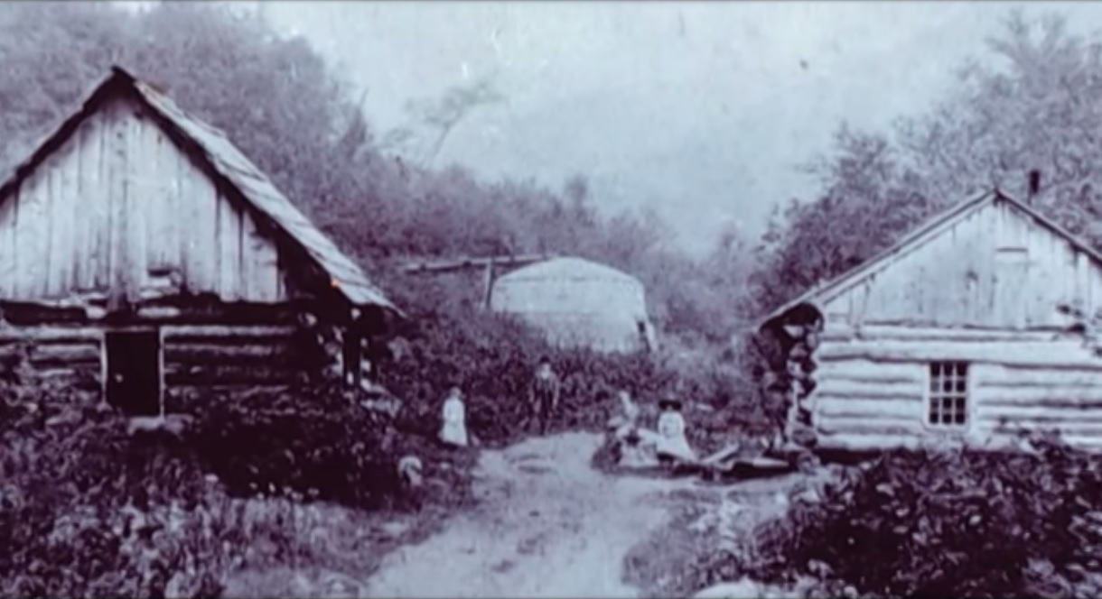
Because they had a mountain of wood to burn, the town embraced the lumber and charcoal industry, and began to slowly prosper as it lured settlement and business. Though Glastenbury town itself is a large area, it only contained 2 small settlements near the western border; the logging town of Fayville in the north, and later, the settlement of South Glastenbury. While Fayville is more known by people looking at a map, South Glastenbury is normally what is profiled in every article I’ve read. The two villages were never connected, the mountainous terrain was so steep that roads were never built.
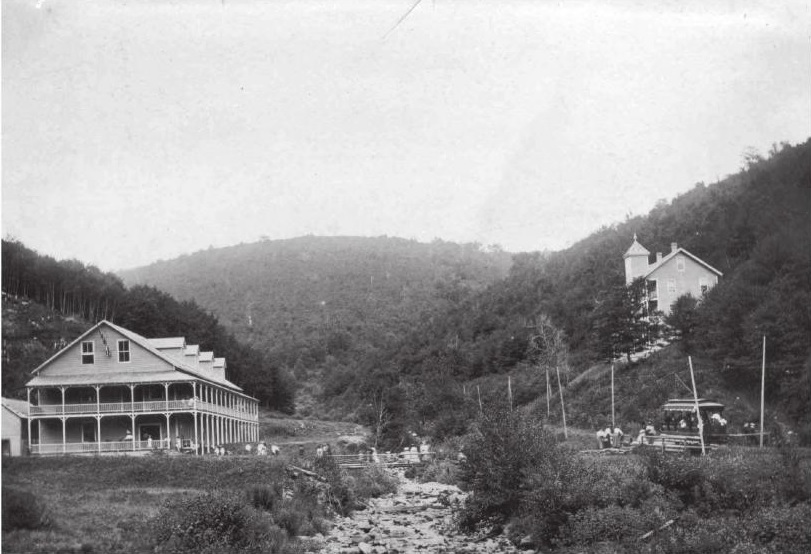
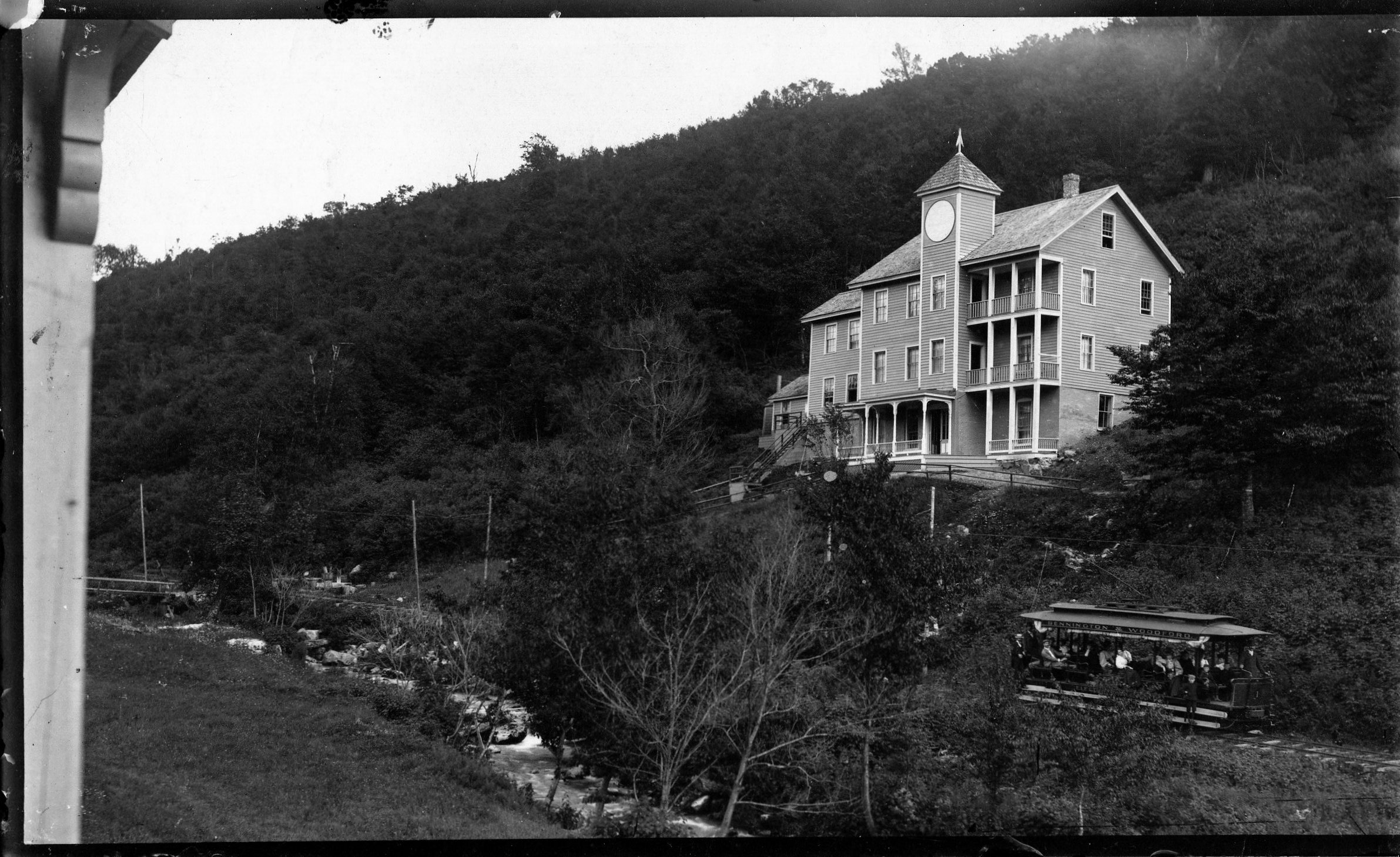
South Glastenbury became the heart of town, and the headquarters of the majority of the charcoal operations, with 12 brick kilns erected along the cleared hillsides. A massive loggers boardinghouse, and company store – the only store in town, were built to serve the village. A few homes, a meetinghouse and a crude one room schoolhouse were also built for the few kids who grew up there. Because South Glastenbury sat at the confluent of two different branches of Bolles Brook, where the headwaters met and began their descent down the mountains, the small village became known as “The Forks”.
Life here was tough. It was a wild town, sort of a last frontier in Vermont. It was the kind of place where men out numbered the women, and the law often didn’t exist.

I’m not willing to pay the $20 image purchase fee – but the website historicmapworks.com has an 1869 Beer atlas map of Woodford that you can check out – and this is one of the few maps I’ve came across to feature South Glastenbury in it. The map is sideways, so look for “District 2”, beyond the Woodford town line, and the black dots that represent buildings plotted around Bolles Brook.

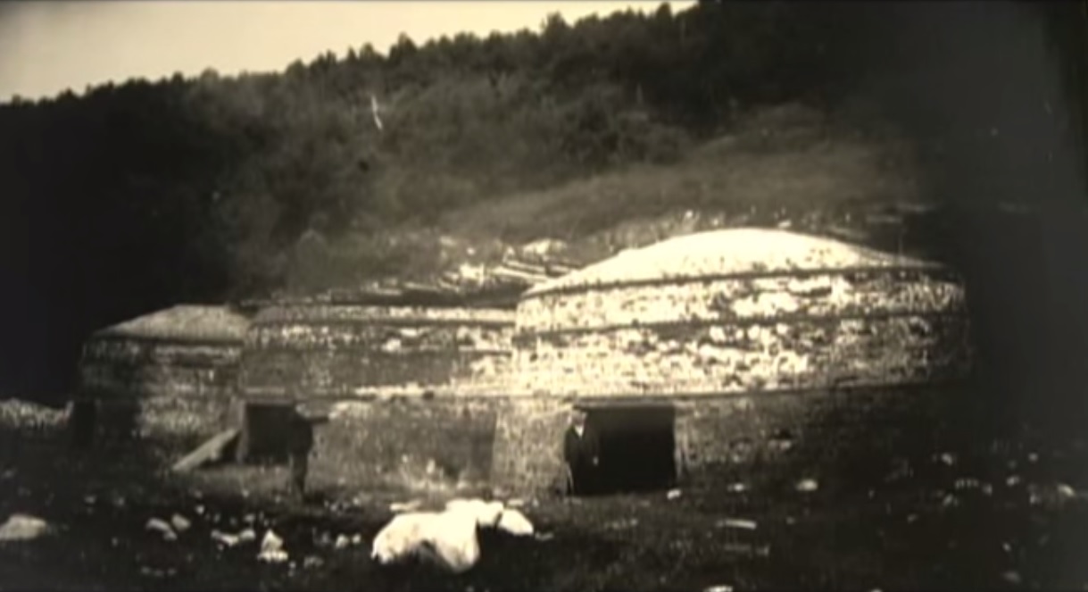
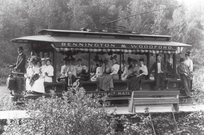
With a profitable timber industry came demands. People needed to get up into town, and lumber and charcoal needed to get down. The steepest railroad ever built in the United States was constructed as the solution, which started out as a sarcastic suggestion turned into a defiant reality. Starting in Bennington and ending at The Forks, The Bennington-Glastenbury Railroad was formed in 1872, the tracks climbing an astonishing 250 feet per mile at 9 miles long. But depending on a finite resource eventually created the end of the charcoal and logging industry and the mountains were logged until nothing larger than a sapling remained on the slopes.
But the railroad was still around, and they wanted money. The question was, what to do with it? In 1894, the railroad re-billed itself as The Bennington-Woodford Electric Railroad and the town reinvented itself as a tourist destination, using the railroad as a way to bring tourists up into South Glastenbury. The railroad switched over to using more reliable trolley cars instead of traditional rail cars, because they were stronger and more reliable, especially given the elevation they would have to climb.
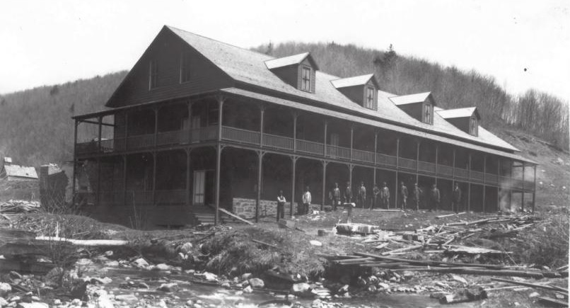
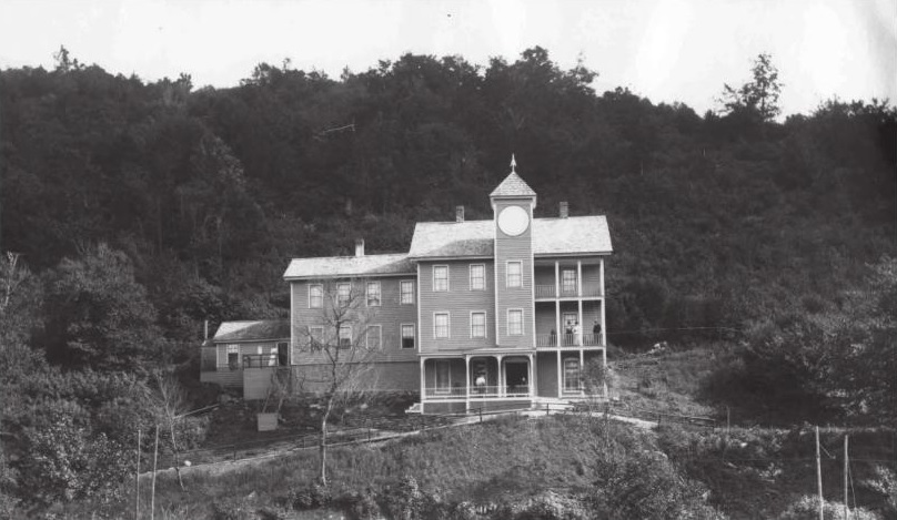
Much time and money were invested into retransforming the town – turning the brawny old loggers’ boarding house into a hotel and the former company store into a casino. No details were overlooked, and both buildings became showpieces. They wanted Glastenbury to stand out from other summer resorts. After painstaking labor and expenses, the town opened up as vacation destination in the summer of 1897, and had a successful first season.
However, the barren mountains stripped of all their trees, were very prone to flooding and soil erosion. A year later, a devastating flood washed out the tracks, putting an end to the town for good. It’s high elevation and isolation ensured that no one tried to rebuild it, and the buildings fell into ruin under the silence of the mountains.


The population of Glastenbury dwindled down to almost nothing, which later got the attention of Ripley’s Believe It Or Not in the 1930s when they learned that all 3 members of the Mattison Family were the entire town, and held every office. Because of this, the state of Vermont disorgonized the town in 1937, the first time the state ever did such an act, and the area was reclaimed by the wilderness.
It’s even more interesting to think about that a town with such a galvanizing and unique history was actually so tiny in stature. Though many people who write about ghost towns robotically love to use descriptive terms such as “hub” or “thriving”, Glastenbury was really neither – it’s peak population climbed to around 241.
Apart from the town’s fascinatingly unique story line, it may be the obscure and inexplicable events that allegedly happened on it’s slopes that has really given the town it’s considerable attention. The area has since given birth to terrifying legends, if not actual monsters.


“The Bennington Triangle”
While my love of maps inadvertently lead me to my interest of Glastenbury, their ability to organize information and draw conclusions was useless here.
Glastenbury Mountain and the surrounding area has long been considered one of Vermont’s most haunted places. In 1992, local author and folklorist Joseph Citro coined the term “The Bennington Triangle” to describe the area, and the designation not only stuck, it grew immensely in popularity. Over the years, the phrase has been been featured in books, websites and television shows, to the point where the name has taken a life of it’s own.
The theories and enthusiasm have quickly escalated and have continued to morph and stoke the fire. Many are quick to glamorize the region without being objective, only further propelling it into the blurred haze of fact and embellishment.
To better understand the hysteria here, let me try to summarize the more colloquial regional portrait for you.
It started with the native Americans, who refused to venture onto Glastenbury mountain. Fearing the land was cursed, they only used the land to bury their dead. But maybe it was because of a cross wind that met on the summit of the mountain. Even today, hunters will tell you that because of the disorienting winds, it’s very easy to get lost in the woods.
There is also a baffling legend of some sort of enchanted stone somewhere in the mountains, which is said to open up and “swallow” a human being in seconds if it’s stepped on. Another reason they avoided the place.
The weirdness continued when colonial settlers came to the area, whose vague and un-researchable accounts tell of weird sounds, noises and odors that would come from the mountain. But there are human things at work here as well, and those have been documented.
In 1867, there was an alleged wild man sighting, where a mysterious misanthropic specter would venture down from the woods (some accounts say he lived in a cave in Somerset) pull back his coat, and expose himself to unsuspecting women in Glastenbury and nearby Bennington. He was also said to brandish a revolver for intimidation. Whoever he was, he was eventually ran out of town and faded into obscurity.
On April 4th, 1892, Fayville mill worker Henry McDowell went haywire and murdered John Crawley by bashing him in the head with either a piece of wood or a rock, depending on the story. He fled town, but was later apprehended in South Norwalk, Connecticut, where he made a full confession. However, he was babbling on about voices in his head that wouldn’t leave him alone, and as a result, was sentenced in the Vermont State Asylum in Waterbury. But he escaped by hiding in a railroad car carrying a load of coal, never to be seen again. Some say he returned to Glastenbury, and others claim that he still remains hiding on the slopes to this very day. But by now, he would be an impossibly old man, which takes on an eerie resemblance to the tale of Doctor Benton coming from the mountains of New Hampshire.
On the opening day of Vermont’s first hunting season in 1897, 40 year old John Harbour, a respected Woodford resident, was mysteriously murdered at his deer camp in Bickford Hollow, a remote area in the hills south of Glastenbury. While hunting with his brother and family friend, they heard the blast of a rifle, followed by him crying out “I’ve been shot!”. They immediately turned around and searched for him, but it wasn’t until 11 AM the next morning when they found him, his legs protruding out from underneath a Cedar tree. However, something wasn’t quite right. His loaded gun sat neatly beside him, as if it was purposely put there. But something was wrong. His body was a distance away from where he was shot. They now knew that John had to have been moved. But by what? Did he crawl there after being shot? Did he receive human help, possibly by the shooter? There were no signs of him having walked or crawled to his final resting place, no clues at all. The mystery remains unsolved to this day.
It was after these two murders that signaled both the beginning of Glastenbury’s slow decline, and the establishment of it’s reputation as a mysterious and haunted place. Sometime in the early 19th century, a stagecoach full of passengers were making their way over the mountains near Glastenbury, near present day Route 9 in Woodford. It was well past dark and a violent rain storm was washing out the road. The rain was coming down so hard, it soon forced the driver to slow down to a crawl as the thunder cracked the night sky. Things became so bad that the driver eventually came to a complete stop in the dark and wet mountain wilderness. As he hopped down from his perch with the lantern to get a good idea of the situation, he noticed something peculiar illuminated by lantern light. There were unfamiliar footprints in the mud just ahead of him.
The rain hadn’t washed them away yet, so they had to be fresh tracks the driver reckoned. His observations revealed that the tracks were widely spaced, suggesting that whatever had made them was tremendous in size. He noticed the horses were beginning to get spooked, but he just couldn’t stop thinking about those tracks. What made them? He soon hollered back to the passengers and asked for their opinions. At this point, the horses were going wild, which was spooking the driver. That meant that something was skulking nearby, and it might just be what made those tracks…
As the passengers began to step out, something dealt a savage blow to the side of the carriage. Now, all of the passengers scrambled out of the carriage, completely terrified. The blows kept coming, until the whole thing tumbled over on it’s side.
The quivering passengers and driver huddled together in the dark, the rain stinging their faces. Then the creature came into view. Though it was almost impossible to see, two large eyes could be made out staring at them. A vague detail described the brazen creature as roughly 8 feet tall and hairy, before it shambled back into the woods. Shortly after, whatever had attacked them had became dubbed as The Bennington Monster.
Another interesting theory suggests that the Bennington Monster is actually the horrifying transformation of the Glastenbury Wild Man. After he was chased out of the region, he took back to the woods and dwelled, becoming cannibalistic, deformed and insane, wearing animal firs and attacking lone stagecoaches coming over the mountains.
Strange Disappearances
Giant hairy monsters that topple stagecoaches are all good for earning a place an official spook status, but it was the disconcerting events that took place after the town became disorganized in 1937 that have really cemented the area into the public’s imagination and paranormal concrete.
Glastenbury is where one of Vermont’s most frightening mysteries took place, and what’s more captivating is that it really didn’t happen all that long ago. Beginning in the last cold months of 1945, people from the area began to vanish without a trace.
The first one to disappear was 74 year old Middie Rivers. He was a native to the area and worked as a hunting and fishing guide. Because of his job, he was completely familiar with the woods. One day, Rivers led four hunters up onto the mountain. Things were going fine, until their trek back to camp. Rivers got a bit ahead of the group, and vanished completely. Expecting to catch up with him at the camp, the hunters began to panic when they didn’t see him there upon their arrival. Police and a group of volunteers combed the area for hours. But Rivers was an experienced woodsman, so they were fairly confident they would find him in no time. But search attempts continued for over a month, and no trace was ever found. Local lore has it that Rivers disappeared near Bickford Hollow, the same place John Harbour was murdered.
The next person to vanish is the most infamous of all the Bennington Triangle disappearances, the case most talked about. on December 1, 1946, 18 year old Paula Welden decided to take a hike on the Long Trail. she left her dorm at Bennington College and walked into the woods. She was easy to spot, because of her bright red coat. Plenty of people saw her that day, including on the Long Trail itself. But Monday came, and Paula didn’t show up for her classes. The college called the sheriff’s department. 400 students and faculty members assembled to help look for their missing classmate. A massive search party of 1,000 people, bloodhounds, helicopters and even a clairvoyant, combed the area diligently for weeks. A $5,000 reward was even offered! But on December 22, all efforts came to an end. There was no body, no clothes, no evidence, nothing. The quality of Paula Weldon’s search party was met with scrutiny, and because of this, it lead to the formation of the Vermont State Police. Another interesting detail I uncovered was that to this day, there are people who think it’s bad luck to wear red while hiking Glastenbury Mountain.

The third person to disappear was on Columbus Day in 1950. 8 year old Paul Jepson was waiting for his mother in his family’s pickup at the dump they were caretakers for. But when she came back, he was gone. Like Paula Welden, Paul was wearing a red jacket, so he should have been easy to spot, but Mrs. Jepson couldn’t find him anywhere. Frantic, she called for help, and another search was launched.
Hundreds of townsfolk joined the search, scanning the dump and the surrounding roads, even the mountains. They implemented a double check system, where as soon as one group finished searching an area, another group would search the same area. Even coast guard planes were brought in. But all was useless. Bloodhounds borrowed from the New Hampshire State Police lost Paul’s scent at the intersection of East and Chapel Roads. Local lore says that Paul’s scent was actually lost at the same place Paula Welden was last seen. After the search had been called off, Paul’s father disclosed a peculiar piece of information. Paul had mentioned that he had an inexplicable “yen” to go into the mountains lately. Paul’s disappearance made him the third to go missing in roughly the same area. Was there a pattern here?
Maybe. Or maybe not. It was said that there were pigs at the dump his family were caretakers for. One popular theory at the time which the newspapers suggested, was that Paul wondered off and was eaten by the pigs, thus explaining his disappearance.
Others speculate that Paul was actually abducted near East and Chapel Roads, carried away in a car. That would explain why the bloodhounds lost his scent. But we’ll never know for sure. Either way, the newspapers did what they do best and ran wild, and soon, others started to wonder what was going on here?
Two weeks later, On October 28th, 53 year old Freida Langer had left her family’s camp east of Glastenbury Mountain near the Somerset Reservoir to go hiking with her cousin. She was an experienced woodsman and was completely familiar with the area. About a half mile from camp, she slipped and fell into a stream. She decided to hike the short half mile back to camp, change her clothes and catch back up. She never returned.
When her cousin got back to camp, he was startled to learn that not only had she never came back, but no one even saw her come out of the woods.
Local authorities were quick to launch another search, alarmed at another unfathomable disappearance in the area. Once again, all efforts proved to be hopeless. They found nothing. The Bennington Banner picked up on the story, and raised a disturbing question: How did Langer disappear completely in an area she was so familiar with?
More Disappearances
On December 1st, 1949, James E. Tetford had been visiting relatives in northern Vermont. He boarded a bus in St. Albans, en route to the Bennington Soldiers home, where he lived. But he never arrived. Somehow, he had vanished without a trace without ever getting off of the bus. Even the bus driver had no explanation!
This account seems to be continuously accepted as proof of paranormal happenings, without further questioning the events. It’s worth mentioning that by the time James was actually reported missing, it was at least a week after the fact, when the Bennington soldiers home finally decided to call his relatives to figure out if he was actually coming back or not. By the time the police were involved in the investigation and got around to interviewing the bus driver and other passengers, it had been two weeks, and no one really remembered anything. But some information did arise. James was last seen by a friend of his when his bus made a stop in Burlington, and guessed he might have gotten off there, offering another possible explanation to his whereabouts. But regardless, his disappearance still remains a mystery. I don’t really see a connection here to the other disappearances, but I guess because it happened around the same time frame and James did live in the area, it has just been lumped into the big picture.
And perhaps one of the most arcane disappearance took place on November 11, 1943. As Author David Paulides tells in his book Missing 411, 37 year old Carl Herrick went hunting in the woods of West Townshend, about 10 miles northeast of Glastenbury. At some point during the hunt, Herrick and his cousin, Henry, were separated. Henry eventually made it back to camp, but Carl didn’t show up. As dusk began to fall and Carl still hadn’t arrived, Henry immediately contacted law enforcement, just as the snow began to fall.
The search for Carl lasted three days without finding a trace. But towards dusk on the third day, Henry stumbled upon Carl’s body. He was laying on the ground in the woods, motionless, his loaded rifle found leaning against a tree seventy feet away. Henry reported finding “huge bear tracks” around Carl’s body, but the official postmortem was baffling. Carl was reportedly squeezed to death, his lung was found to be punctured by his own ribs. What sort of bear squeezes a human to death? It would be an impossible act.
In Joseph Citro’s Passing Strange, (which was another heavy source for this article) he further mentioned a Burlington Free Press article dated October 25, 1981 reported that a trio of hunters disappeared somewhere near Glastenbury, and not surprisingly, that too remains unsolved.
Additional Theories and Searching for Answers
If you take these other accounts into consideration, this raises the number of disappearances from four to nine, which begs the question, what happened here? Where could nine people vanish to without a trace?
This is what we do know. The victims ages ranged between 8 and 74 and were evenly divided between men and women. Time is also a pattern. The disappearances all happened during the same time of the year – the last 3 months – and many of them were last seen between 3 and 4 PM. The rest is up for debate.
Because of the vast scope of the wilderness area and it’s inaccessibility, the task of finding a body is difficult. The conditions could easily ensure that someone’s remains would never be found again, regardless of cause of death. Depending on who you ask, there is a pattern there.
Speculations abound, adding many more layers to this fabled region’s already weighted and transgressive reputation. Could the Bennington Monster still be stalking the slopes, carrying its victims to some cave on the mountain? Maybe. As recently as 2003, Winooski resident Ray Dufresne saw something peculiar on his drive down Route 7, near Glastenbury. What he first thought was a homeless man stumbling around in a snowsuit, turned into an alleged bigfoot sighting upon a closer look. That story immediately blew up and was even picked up by local news stations. While some skeptics dismiss it as a prankster in a Gorilla suit, others aren’t buying it, and plenty more sightings have been passed down by word of mouth from the Bennington area, all which remain unaccounted for.
Or maybe, could these unfortunate people have accidentally encountered that enchanted Indian stone, and were swallowed in seconds?
Alien abduction is another hypothesis. Many reports of UFO sightings and strange lights in the sky have been spotted over the Glastenbury wilderness over the last century. Most notably, a “flying silo” shaped anomaly was see over the skies of Bennington by Don Pratt in 1984, which seems to be the go-to example for extraterrestrial sightings in the area.
But my personal favorite was designated by John A. Keel, an American journalist and influential UFOlogist, who used the term “Window Areas” to describe these places, or, some sort of inter-dimensional doorway or vortex into another world. New England seems to have a fair share of them. The legendary Bridgewater Triangle in Massachusetts which has similar phenomena, and the summit of Mount Washington are two of the most notable.
Perhaps the most tangible answer could be something all too familiar, a serial killer. “The Bennington Ripper” and “The Mad Murderer of The Long Trail” were all monikers given to the possibility of a sinister suspect that lurked in the wilds, but no evidence was ever found to prove this. The police during that time were not familiar with serial killers or how they operated, so even if it was the work of such a killer, the facts would have gone undocumented.
Adding to the seemingly ever growing list of theories, this one might be the most plausible. Near the former village of South Glastenbury, there are a few old wells. Some speculate that Middie Rivers accidentally tumbled down a well while on his hunting trip. His party, being unfamiliar with the area, never thought to check. As for the others….
An odd footnote to all of this; the body of Freida Langer did eventually appear, seven months after she had vanished. But sadly, this wouldn’t be of any help. It was in an area that search parties knew they had combed thoroughly, near the flood gates of the Somerset Reservoir. It was a completely open area, and anything there would be impossible to miss. And yet, here she was. Or, what was left of her. Her remains were in such gruesome condition that no cause of death could ever be determined.
Even More Strangeness
Enigmatic situations aren’t contained to the past, things reportedly continue to happen here to this day. Countless internet searches have dug up numerous unusual tales posted on message boards and blogs from hikers, hunters and curiosity seekers.
In the book Haunted Hikes of Vermont, Author Tim Simard mentions a one time incident of hearing a ghostly train whistle while hiking along the West Ridge Trail, miles away from both any functional railroad track, and the old rail bed that runs up into South Glastenbury.
One harrowing account I was able to dig up took take place on Columbus Day in 2008. This time, 2 Long Trail hikers were making their way through the Glastenbury wilderness. While hiking, they ran into a young man named Dave, who helped rebuild fire towers along the trail. They started talking about the mountain’s reputation, which at this point seems almost impossible not to do if you’re visiting. They had heard about the disappearances and shrugged it off as out of control tall tales. But Dave had a weird story to tell of his own. Dave spent some time on Glastenbury mountain restoring the fire tower on the summit, and would work up there for extended periods of time.
While camping in Goddard Shelter, his friends reported that there were nights that he would sit up in his sleep and laugh uncontrollably, and other nights when he would wake up screaming. Dave was considered a down to earth and smart guy, so this behavior had his friends extremely concerned, and disturbed. He had never acted in such a way before. I’ll never know if Dave had any follow up episodes, or an explanation behind these bizarre actions, the thread ended there.
Another story I was able to dig up only adds to the unscrupulousness of the region. In the book Ghost towns of New England, Author Fessenden S. Blanchard spoke with Arlie Greene – the oldest surviving member of the Mattison family. Greene recalled the old days in Glastenbury, and one particularly enigmatic, and possibly nefarious, incident. Two local men went fishing on the Peters Branch – one went upstream and the other went downstream. One of them was never seen again. A short time after the disappearance of the fisherman, someone found a human skull sitting on a tree stump near the brook. Some speculated Panthers got to him, but others weren’t so sure…
Arcane Stone Cairns
Yet another mystery, dressed in the forest light and acting as silent witnesses to times gone by. This enigma is far more benign than the previous ones I’ve covered, but is still just as vexing. There are a series of inexplicable cairns scattered around the mountain, and no one is quite sure why they exist. There are theories to why they are there. Farmers built them long ago while clearing their pastures, or several passing hikers on the Long Trail built them, to act as beacons in bad weather. But nothing adds up. The cairns were built in high elevations where farming never took place, and most of them are located miles away from the long trail in heavily forested areas. So what are they? The work of the Bennington Monster? Perhaps playful hikers built them wanting to add another Glastenbury mystery? For now, these giant piles of stones offer no explanations.

What About Today?
Though Glastenbury is a ghost town and designated wilderness area, it’s anything but deserted. A myriad of outdoor enthusiasts, hikers, snowmobiliers, college students, history buffs, paranormal investigators and hunters all flock here to the undisturbed wilderness – trekking up the expansive network of forest roads, hiking trails or silent waterways, all realizing just how special it is here.
Today, there are about 8 residents that chose to live in this strange paradise. They love it’s obscurity, and I can see why. There are no other towns quite like Glastenbury in the northeast – and with only one road in town, a winding dirt road that snakes its way in no less than 2 miles, privacy is in abundance. And if you know about Glastenbury, there seems to be a sense of pride that comes with your knowledge of this obscure area, if not something that conjures a romantic notion of fantasy. As a matter of fact,”Chateau Fayville”, the last original house in Glastenbury and the former Mattison homestead, was put on the real estate market – and it looks like a nice place.
But there are several people who aren’t all that enthusiastic about its menacing repute and “Bennington Triangle” folklore – mostly because they’re not a fan of ghosts, curses and the bad, inflated outlook it brings to the area. Skeptical people will be quick to assure you that everything has a perfectly logical explanation. As for me, I’m one of the skeptics.
So, is there truly something phenomenal about Glastenbury that has yet to be comprehensively explained? Do curses and monsters really claim their victims? Well….this seems to be a controversial subject of much enthusiastic debate. I’ve heard it all. At the end of the day, some people surmise firmly to their untenable thoughts. I suppose it’s all subjective.
During the height of the disappearances, the local media ran wild with the stories and theories, which not surprisingly, got out of hand, creating vicious accusations and conspiracy theories. If you’re a fact checker, it’s worth noting that Middie Rivers was the only actual person to vanish within the town of Glastenbury itself. All the others were in neighboring communities, many on the Long Trail in Woodford.
To add to this, Author Tyler Resch is one of those who thinks the area is widely exaggerated, and has created preposterous theories carried by inertia. He once noted that he was surprised that more people actually hadn’t vanished, because the wilderness is in fact so large, and it’s very easy to become hopelessly lost if you stray from the trails.
Others argue that numerous things could have happened to the missing hikers. They could have fallen down an old well, or gotten lost and frozen to death, perhaps taking shelter in one of the numerous caves on the mountain which few people ever venture near. Another theory is that they were the unfortunate meals of a Catamount or giant cat, which would surely dispose of any evidence of a body.
If you put all of these pieces that I’ve covered together and add the intrigue of a town attempting to survive against all odds but still vanishing into the wilderness, you can easily draw a conclusion about something creepy and supernatural existing here. After all, the region does have great triggers for spook stories. I’m personally awe struck that such a plethora of incidents are all linked to a single area.
But at the end of the day, everything is relative. 4 hikers did disappear, and people have claimed to see weird things in the woods. The only absolute truth about all of this is that people swear these things happened. Whether the culprit was something awesome and sinister or innate, is the quandary here. Who knows for sure.
In finality, the Bennington Triangle certainly isn’t in danger of being forgotten anytime soon.
Additional Stuff! (Because this entry wasn’t nearly long enough)
Youtuber Matt Garland made this awesome documentary on the Bennington Triangle, which is in my opinion, a great watch.
—————————————————————————————————————————————–
To all of my amazing fans and supporters, I am truly grateful and humbled by all of the support and donations through out the years that have kept Obscure Vermont up and running.
As you all know I spend countless hours researching, writing, and traveling to produce and sustain this blog. Obscure Vermont is funded entirely on generous donations that you the wonderful viewers and supporters have made. Expenses range from internet fees to host the blog, to investing in research materials, to traveling expenses. Also, donations help keep me current with my photography gear, computer, and computer software so that I can deliver the best quality possible.
If you value, appreciate, and enjoy reading about my adventures please consider making a donation to my new Gofundme account or Paypal. Any donation would not only be greatly appreciated and help keep this blog going, it would also keep me doing what I love. Thank you!
Gofundme: https://www.gofundme.com/b5jp97d4
![]()